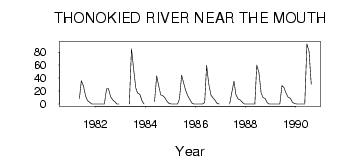
| PointID: | 3574 | Code: | 07RC001 | Latitude (decimal degrees): | 64.14 | Longitude (decimal degrees): | -108.91 | Drainage Area (km2): | 1780.00 | Source: | Hydat | Hydrological Zone: | Mackenzie | Name: | THONOKIED RIVER NEAR THE MOUTH |
|---|
| Download | |
|---|---|
| Site Descriptor Information | Site Time Series Data |
| Link to all available data | |
| ID | Year | Jan | Feb | Mar | Apr | May | Jun | Jul | Aug | Sep | Oct | Nov | Dec |
|---|---|---|---|---|---|---|---|---|---|---|---|---|---|
| 3574 | 1980 | 0.00 | |||||||||||
| 3574 | 1981 | 8.28 | 35.90 | 27.90 | 11.90 | 5.24 | 2.79 | 0.00 | 0.00 | ||||
| 3574 | 1982 | 0.00 | 0.00 | 0.00 | 0.00 | 0.10 | 23.20 | 23.70 | 11.30 | 6.47 | 3.48 | 0.00 | 0.00 |
| 3574 | 1983 | 0.29 | 84.90 | 53.70 | 24.40 | 16.70 | 14.90 | 5.00 | 0.00 | ||||
| 3574 | 1984 | 3.69 | 43.30 | 28.40 | 14.30 | 12.60 | 9.59 | 4.00 | 1.00 | ||||
| 3574 | 1985 | 0.00 | 0.00 | 0.00 | 0.00 | 8.28 | 44.30 | 31.60 | 20.70 | 12.20 | 6.30 | 1.00 | 0.00 |
| 3574 | 1986 | 0.00 | 0.00 | 0.00 | 0.00 | 2.38 | 59.70 | 30.60 | 14.00 | 9.63 | 5.86 | 1.00 | 0.00 |
| 3574 | 1987 | 1.0e-03 | 17.70 | 35.20 | 14.90 | 7.73 | 6.27 | 3.00 | 0.00 | ||||
| 3574 | 1988 | 0.00 | 0.00 | 0.00 | 0.00 | 0.05 | 60.00 | 48.60 | 17.60 | 9.94 | 8.58 | 2.00 | 0.00 |
| 3574 | 1989 | 0.00 | 0.00 | 0.00 | 0.00 | 0.27 | 28.60 | 25.60 | 16.80 | 10.60 | 8.90 | 3.00 | 1.00 |
| 3574 | 1990 | 0.00 | 0.00 | 0.00 | 0.00 | 0.20 | 92.50 | 80.70 | 30.30 |
 Return to R-Arctic Net Home Page