| PointID: | 357 | Code: | 05BN019 | Latitude (decimal degrees): | 50.14 | Longitude (decimal degrees): | -111.68 | Drainage Area (km2): | Source: | Hydat | Hydrological Zone: | Nelson | Name: | ROLLING HILLS CANAL NO. 2 SPILL |
|---|
| Download | |
|---|---|
| Site Descriptor Information | Site Time Series Data |
| Link to all available data | |
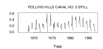
| ID | Year | Jan | Feb | Mar | Apr | May | Jun | Jul | Aug | Sep | Oct | Nov | Dec |
|---|---|---|---|---|---|---|---|---|---|---|---|---|---|
| 357 | 1966 | 0.29 | 0.28 | ||||||||||
| 357 | 1968 | 0.11 | 0.01 | 0.07 | 0.22 | 1.0e-03 | 1.0e-03 | ||||||
| 357 | 1969 | 0.09 | 0.26 | 0.30 | 0.19 | 0.12 | 0.10 | ||||||
| 357 | 1970 | 0.13 | 0.06 | 0.25 | 0.30 | 0.41 | 0.06 | ||||||
| 357 | 1971 | 0.11 | 0.28 | 0.21 | 0.20 | 0.00 | 0.02 | ||||||
| 357 | 1972 | 0.19 | 0.28 | 0.16 | 0.25 | 0.19 | 0.10 | ||||||
| 357 | 1973 | 0.29 | 0.38 | 0.34 | 0.60 | 0.09 | 0.00 | ||||||
| 357 | 1974 | 0.18 | 0.23 | 0.32 | 0.60 | 0.22 | 0.20 | ||||||
| 357 | 1975 | 0.02 | 0.27 | 0.15 | 0.26 | 0.31 | 0.10 | ||||||
| 357 | 1976 | 0.18 | 0.29 | 0.20 | 0.20 | 0.14 | 0.32 | ||||||
| 357 | 1977 | 0.11 | 0.22 | 0.25 | 0.26 | 0.07 | 0.06 | ||||||
| 357 | 1978 | 0.12 | 0.17 | 0.31 | 0.26 | 0.10 | 0.13 | ||||||
| 357 | 1979 | 0.22 | 0.28 | 0.35 | 0.29 | 0.17 | 0.13 | ||||||
| 357 | 1980 | 0.24 | 0.18 | 0.54 | 0.38 | 0.15 | 0.05 | ||||||
| 357 | 1981 | 0.46 | 0.38 | 0.50 | 0.44 | 0.24 | 0.14 | ||||||
| 357 | 1982 | 0.28 | 0.31 | 0.45 | 0.51 | 0.28 | 0.17 | ||||||
| 357 | 1983 | 0.15 | 0.38 | 0.45 | 0.44 | 0.37 | 0.14 | ||||||
| 357 | 1984 | 0.26 | 0.31 | 0.36 | 0.35 | 0.17 | 0.07 | ||||||
| 357 | 1985 | 0.13 | 0.41 | 0.34 | 0.32 | 0.03 | 0.03 | ||||||
| 357 | 1986 | 0.20 | 0.26 | 0.24 | 0.20 | 0.15 | 0.01 |
 Return to R-Arctic Net Home Page