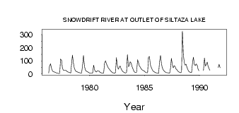
| PointID: | 3567 | Code: | 07QB002 | Latitude (decimal degrees): | 62.17 | Longitude (decimal degrees): | -109.86 | Drainage Area (km2): | 9110.00 | Source: | Hydat | Hydrological Zone: | Mackenzie | Name: | SNOWDRIFT RIVER AT OUTLET OF SILTAZA LAKE |
|---|
| Download | |
|---|---|
| Site Descriptor Information | Site Time Series Data |
| Link to all available data | |
| ID | Year | Jan | Feb | Mar | Apr | May | Jun | Jul | Aug | Sep | Oct | Nov | Dec |
|---|---|---|---|---|---|---|---|---|---|---|---|---|---|
| 3567 | 1976 | 7.00 | 60.10 | 76.70 | 44.90 | 24.30 | 18.00 | 15.30 | 13.00 | 9.00 | |||
| 3567 | 1977 | 6.00 | 5.00 | 4.00 | 3.00 | 114.00 | 103.00 | 43.40 | 29.30 | 28.10 | 27.90 | 26.00 | 19.00 |
| 3567 | 1978 | 15.00 | 12.00 | 10.00 | 7.00 | 78.90 | 144.00 | 81.50 | 44.80 | 25.00 | 19.30 | 17.00 | 13.00 |
| 3567 | 1979 | 10.00 | 8.00 | 6.00 | 6.00 | 70.00 | 141.00 | 57.90 | 30.30 | 22.20 | 17.70 | 14.00 | 9.00 |
| 3567 | 1980 | 6.00 | 5.00 | 5.00 | 7.00 | 66.80 | 33.50 | 19.20 | 14.50 | 22.70 | 23.80 | 21.00 | 12.00 |
| 3567 | 1981 | 8.00 | 7.00 | 6.00 | 6.00 | 81.70 | 101.00 | 78.20 | 60.30 | 46.20 | 38.70 | 28.00 | 20.00 |
| 3567 | 1982 | 13.00 | 9.00 | 7.00 | 5.00 | 11.10 | 124.00 | 61.30 | 35.50 | 51.50 | 60.70 | 39.00 | 26.00 |
| 3567 | 1983 | 18.00 | 13.00 | 9.00 | 7.00 | 12.50 | 147.00 | 56.60 | 62.20 | 92.70 | 82.50 | 56.00 | 37.00 |
| 3567 | 1984 | 21.00 | 13.00 | 10.00 | 14.00 | 108.00 | 87.60 | 61.40 | 50.80 | 39.00 | 30.30 | 26.00 | 24.00 |
| 3567 | 1985 | 16.00 | 11.00 | 9.00 | 9.00 | 127.00 | 133.00 | 69.00 | 48.50 | 33.40 | 21.70 | 16.00 | 12.00 |
| 3567 | 1986 | 9.00 | 7.00 | 6.00 | 5.00 | 90.20 | 141.00 | 84.30 | 48.50 | 30.80 | 22.30 | 15.00 | 11.00 |
| 3567 | 1987 | 9.00 | 8.00 | 7.00 | 6.00 | 43.90 | 119.00 | 70.00 | 45.70 | 62.80 | 56.20 | 39.00 | 30.00 |
| 3567 | 1988 | 21.00 | 15.00 | 11.00 | 9.00 | 15.30 | 328.00 | 144.00 | 86.60 | 67.20 | 73.40 | 49.00 | 30.00 |
| 3567 | 1989 | 19.00 | 14.00 | 11.00 | 10.00 | 89.00 | 128.00 | 73.00 | 63.50 | 75.70 | 66.00 | 39.00 | 24.00 |
| 3567 | 1990 | 25.80 | 121.00 | 59.90 | 71.90 | 90.50 | 59.90 | 40.00 | 28.00 | ||||
| 3567 | 1991 | 48.50 | 73.60 | 48.00 |
 Return to R-Arctic Net Home Page