| PointID: | 3563 | Code: | 07PA002 | Latitude (decimal degrees): | 60.00 | Longitude (decimal degrees): | -115.57 | Drainage Area (km2): | 3410.00 | Source: | Hydat | Hydrological Zone: | Mackenzie | Name: | WHITESAND RIVER NEAR ALTA/NWT BOUNDARY |
|---|
| Download | |
|---|---|
| Site Descriptor Information | Site Time Series Data |
| Link to all available data | |
| ID | Year | Jan | Feb | Mar | Apr | May | Jun | Jul | Aug | Sep | Oct | Nov | Dec |
|---|---|---|---|---|---|---|---|---|---|---|---|---|---|
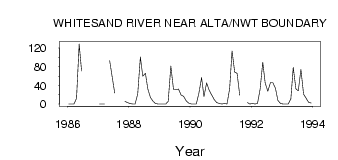
| 3563 | 1986 | 0.00 | 0.00 | 0.00 | 12.00 | 129.00 | 71.00 | ||||||
| 3563 | 1987 | 0.00 | 0.00 | 0.00 | 93.30 | 57.00 | 23.90 | 6.00 | 3.00 | ||||
| 3563 | 1988 | 1.00 | 0.00 | 0.00 | 22.00 | 101.00 | 60.00 | 66.20 | 32.50 | 14.20 | 5.90 | 1.00 | 0.00 |
| 3563 | 1989 | 0.00 | 0.00 | 0.00 | 6.00 | 81.50 | 31.40 | 31.20 | 32.30 | 19.20 | 16.70 | 7.00 | 2.00 |
| 3563 | 1990 | 0.00 | 0.00 | 0.00 | 24.00 | 56.60 | 16.30 | 45.60 | 30.40 | 19.70 | 9.33 | 3.00 | 1.00 |
| 3563 | 1991 | 0.00 | 1.00 | 0.00 | 33.00 | 114.00 | 68.70 | 65.90 | 19.10 | 3.00 | 0.00 | ||
| 3563 | 1992 | 1.00 | 0.00 | 1.00 | 32.00 | 89.70 | 45.50 | 27.40 | 46.10 | 45.80 | 33.80 | 8.00 | 1.00 |
| 3563 | 1993 | 0.00 | 0.00 | 0.00 | 11.00 | 78.80 | 32.60 | 28.70 | 74.20 | 21.20 | 12.90 | 4.00 | 2.00 |
 Return to R-Arctic Net Home Page