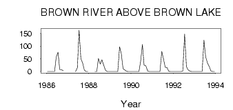
| PointID: | 3551 | Code: | 06OA006 | Latitude (decimal degrees): | 66.04 | Longitude (decimal degrees): | -91.83 | Drainage Area (km2): | 2040.00 | Source: | Hydat | Hydrological Zone: | Northwest Hudson Bay | Name: | BROWN RIVER ABOVE BROWN LAKE |
|---|
| Download | |
|---|---|
| Site Descriptor Information | Site Time Series Data |
| Link to all available data | |
| ID | Year | Jan | Feb | Mar | Apr | May | Jun | Jul | Aug | Sep | Oct | Nov | Dec |
|---|---|---|---|---|---|---|---|---|---|---|---|---|---|
| 3551 | 1986 | 0.00 | 0.00 | 0.00 | 0.00 | 0.00 | 57.40 | 76.00 | 8.32 | 7.55 | 2.52 | ||
| 3551 | 1987 | 0.00 | 15.10 | 163.00 | 51.00 | 32.50 | 5.42 | 0.00 | 0.00 | ||||
| 3551 | 1988 | 0.00 | 0.00 | 51.80 | 29.40 | 46.20 | 25.00 | 4.50 | 0.00 | 0.00 | |||
| 3551 | 1989 | 0.00 | 0.00 | 0.00 | 0.00 | 0.00 | 97.50 | 71.70 | 11.10 | 6.06 | 1.07 | 0.00 | 0.00 |
| 3551 | 1990 | 0.00 | 0.00 | 0.00 | 0.00 | 0.00 | 39.70 | 107.00 | 24.80 | 22.20 | 1.66 | 0.00 | 0.00 |
| 3551 | 1991 | 0.00 | 0.00 | 0.00 | 0.00 | 0.00 | 79.70 | 50.90 | 16.50 | 15.50 | 0.97 | 0.00 | 0.00 |
| 3551 | 1992 | 0.00 | 0.00 | 0.00 | 0.00 | 0.00 | 2.46 | 148.00 | 19.70 | 6.70 | 1.32 | 0.00 | 0.00 |
| 3551 | 1993 | 0.00 | 0.00 | 0.00 | 0.00 | 0.02 | 124.00 | 59.00 | 33.70 | 19.40 | 1.91 | 0.00 | 0.00 |
 Return to R-Arctic Net Home Page