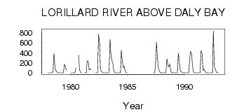
| PointID: | 3546 | Code: | 06OA001 | Latitude (decimal degrees): | 64.29 | Longitude (decimal degrees): | -90.44 | Drainage Area (km2): | 11000.00 | Source: | Hydat | Hydrological Zone: | Northwest Hudson Bay | Name: | LORILLARD RIVER ABOVE DALY BAY |
|---|
| Download | |
|---|---|
| Site Descriptor Information | Site Time Series Data |
| Link to all available data | |
| ID | Year | Jan | Feb | Mar | Apr | May | Jun | Jul | Aug | Sep | Oct | Nov | Dec |
|---|---|---|---|---|---|---|---|---|---|---|---|---|---|
| 3546 | 1978 | 0.00 | 0.00 | 0.00 | 0.00 | 0.07 | 18.70 | 389.00 | 86.20 | 44.60 | 20.10 | 6.00 | 0.00 |
| 3546 | 1979 | 0.00 | 0.00 | 0.00 | 0.00 | 0.00 | 168.00 | 120.00 | 48.40 | ||||
| 3546 | 1980 | 0.00 | 0.00 | 0.00 | 0.00 | 0.00 | 99.20 | 355.00 | 55.40 | 13.00 | 0.00 | ||
| 3546 | 1981 | 0.00 | 0.00 | 0.00 | 240.00 | 237.00 | 60.90 | 80.90 | 58.40 | ||||
| 3546 | 1982 | 0.00 | 0.00 | 0.00 | 772.00 | 599.00 | 62.00 | 23.70 | 12.40 | 0.00 | 0.00 | ||
| 3546 | 1983 | 0.00 | 0.00 | 0.00 | 0.00 | 0.00 | 665.00 | 380.00 | 243.00 | 189.00 | 36.90 | 0.00 | 0.00 |
| 3546 | 1984 | 0.00 | 0.00 | 0.00 | 0.00 | 0.00 | 451.00 | 233.00 | 102.00 | 131.00 | 32.90 | 9.00 | 0.00 |
| 3546 | 1987 | 0.00 | 0.00 | 157.00 | 612.00 | 288.00 | 109.00 | 38.00 | 3.00 | 0.00 | |||
| 3546 | 1988 | 1.00 | 1.00 | 1.00 | 1.00 | 1.01 | 280.00 | 157.00 | 117.00 | 172.00 | 39.60 | 5.00 | 1.00 |
| 3546 | 1989 | 1.00 | 1.00 | 1.00 | 1.00 | 1.00 | 394.00 | 240.00 | 53.60 | 25.30 | 11.40 | 2.00 | 1.00 |
| 3546 | 1990 | 1.00 | 1.00 | 1.00 | 1.00 | 1.00 | 271.00 | 429.00 | 375.00 | 136.00 | 17.70 | 0.00 | 0.00 |
| 3546 | 1991 | 0.00 | 0.00 | 0.00 | 0.00 | 0.07 | 446.00 | 392.00 | 50.10 | 77.00 | 35.70 | 6.00 | 1.00 |
| 3546 | 1992 | 1.00 | 1.00 | 1.00 | 1.00 | 1.50 | 2.26 | 842.00 | 123.00 | 71.10 | 17.50 | 5.00 | 2.00 |
 Return to R-Arctic Net Home Page