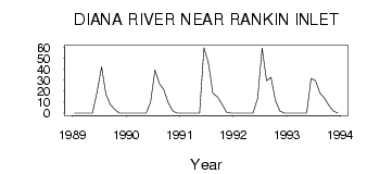
| PointID: | 3545 | Code: | 06NC001 | Latitude (decimal degrees): | 62.86 | Longitude (decimal degrees): | -92.41 | Drainage Area (km2): | 1480.00 | Source: | Hydat | Hydrological Zone: | Northwest Hudson Bay | Name: | DIANA RIVER NEAR RANKIN INLET |
|---|
| Download | |
|---|---|
| Site Descriptor Information | Site Time Series Data |
| Link to all available data | |
| ID | Year | Jan | Feb | Mar | Apr | May | Jun | Jul | Aug | Sep | Oct | Nov | Dec |
|---|---|---|---|---|---|---|---|---|---|---|---|---|---|
| 3545 | 1989 | 0.00 | 0.00 | 0.00 | 0.00 | 0.00 | 18.50 | 42.10 | 17.00 | 7.66 | 3.35 | 0.00 | 0.00 |
| 3545 | 1990 | 0.00 | 0.00 | 0.00 | 0.00 | 0.00 | 10.00 | 39.20 | 27.00 | 21.10 | 9.31 | 2.00 | 0.00 |
| 3545 | 1991 | 0.00 | 0.00 | 0.00 | 0.00 | 3.0e-03 | 59.50 | 45.70 | 18.20 | 14.80 | 8.22 | 1.00 | 0.00 |
| 3545 | 1992 | 0.00 | 0.00 | 0.00 | 0.00 | 0.00 | 13.50 | 59.30 | 29.50 | 32.50 | 11.70 | 2.00 | 0.00 |
| 3545 | 1993 | 0.00 | 0.00 | 0.00 | 0.00 | 3.0e-03 | 31.60 | 29.60 | 18.40 | 13.70 | 7.25 | 2.00 | 0.00 |
 Return to R-Arctic Net Home Page