| PointID: | 3539 | Code: | 06MA004 | Latitude (decimal degrees): | 64.31 | Longitude (decimal degrees): | -95.97 | Drainage Area (km2): | 15.00 | Source: | Hydat | Hydrological Zone: | Northwest Hudson Bay | Name: | AKKUTUAK CREEK NEAR BAKER LAKE |
|---|
| Download | |
|---|---|
| Site Descriptor Information | Site Time Series Data |
| Link to all available data | |
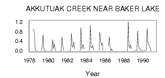
| ID | Year | Jan | Feb | Mar | Apr | May | Jun | Jul | Aug | Sep | Oct | Nov | Dec |
|---|---|---|---|---|---|---|---|---|---|---|---|---|---|
| 3539 | 1978 | 0.91 | 0.73 | 0.03 | 8.0e-03 | 0.00 | |||||||
| 3539 | 1979 | 0.00 | 0.00 | 0.20 | 0.67 | 0.06 | 0.01 | 2.0e-03 | 0.00 | ||||
| 3539 | 1980 | 0.00 | 0.00 | 0.00 | 0.47 | 0.09 | 0.29 | 0.11 | 0.00 | ||||
| 3539 | 1981 | 0.00 | 0.00 | 0.00 | 0.58 | 0.21 | 4.0e-03 | ||||||
| 3539 | 1982 | 0.00 | 0.00 | 0.00 | 0.73 | 0.17 | 0.15 | 0.37 | 0.06 | ||||
| 3539 | 1983 | 0.00 | 0.96 | 0.07 | 0.18 | 0.26 | 0.06 | ||||||
| 3539 | 1984 | 0.00 | 1.07 | 0.12 | 0.13 | 0.23 | 0.03 | ||||||
| 3539 | 1985 | 0.00 | 0.78 | 0.37 | 0.23 | 0.32 | 0.02 | ||||||
| 3539 | 1986 | 0.19 | 0.58 | 0.16 | 0.00 | 0.08 | 0.00 | ||||||
| 3539 | 1988 | 0.00 | 1.22 | 0.17 | 0.11 | 0.25 | 0.07 | ||||||
| 3539 | 1989 | 0.00 | 0.00 | 0.00 | 0.00 | 0.00 | 0.83 | 0.18 | 0.12 | 0.08 | 0.02 | 0.00 | 0.00 |
| 3539 | 1990 | 0.00 | 0.00 | 0.00 | 0.00 | 0.00 | 0.93 | 0.31 | 0.26 | 0.22 | 0.06 | 0.00 | 0.00 |
 Return to R-Arctic Net Home Page