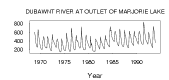
| PointID: | 3532 | Code: | 06KC003 | Latitude (decimal degrees): | 64.26 | Longitude (decimal degrees): | -99.59 | Drainage Area (km2): | 67300.00 | Source: | Hydat | Hydrological Zone: | Northwest Hudson Bay | Name: | DUBAWNT RIVER AT OUTLET OF MARJORIE LAKE |
|---|
| Download | |
|---|---|
| Site Descriptor Information | Site Time Series Data |
| Link to all available data | |
| ID | Year | Jan | Feb | Mar | Apr | May | Jun | Jul | Aug | Sep | Oct | Nov | Dec |
|---|---|---|---|---|---|---|---|---|---|---|---|---|---|
| 3532 | 1968 | 602.00 | 584.00 | 498.00 | |||||||||
| 3532 | 1969 | 407.00 | 341.00 | 295.00 | 269.00 | 253.00 | 264.00 | 661.00 | 641.00 | 499.00 | 437.00 | 378.00 | 306.00 |
| 3532 | 1970 | 252.00 | 228.00 | 213.00 | 203.00 | 198.00 | 371.00 | 406.00 | 435.00 | 505.00 | 471.00 | 378.00 | 283.00 |
| 3532 | 1971 | 252.00 | 248.00 | 247.00 | 240.00 | 235.00 | 440.00 | 505.00 | 455.00 | 401.00 | 352.00 | 307.00 | 265.00 |
| 3532 | 1972 | 228.00 | 197.00 | 178.00 | 174.00 | 179.00 | 445.00 | 551.00 | 431.00 | 406.00 | 386.00 | 364.00 | 341.00 |
| 3532 | 1973 | 313.00 | 288.00 | 264.00 | 252.00 | 258.00 | 413.00 | 446.00 | 399.00 | 380.00 | 308.00 | 225.00 | 180.00 |
| 3532 | 1974 | 157.00 | 146.00 | 142.00 | 150.00 | 211.00 | 450.00 | 392.00 | 364.00 | 307.00 | 255.00 | 218.00 | 194.00 |
| 3532 | 1975 | 179.00 | 174.00 | 177.00 | 194.00 | 303.00 | 584.00 | 495.00 | 402.00 | 402.00 | 360.00 | 281.00 | 216.00 |
| 3532 | 1976 | 173.00 | 154.00 | 153.00 | 182.00 | 266.00 | 700.00 | 645.00 | 488.00 | 470.00 | 391.00 | 291.00 | 232.00 |
| 3532 | 1977 | 199.00 | 190.00 | 192.00 | 219.00 | 311.00 | 534.00 | 473.00 | 406.00 | 392.00 | 409.00 | 362.00 | 316.00 |
| 3532 | 1978 | 273.00 | 242.00 | 231.00 | 237.00 | 259.00 | 376.00 | 724.00 | 555.00 | 435.00 | 318.00 | 242.00 | 207.00 |
| 3532 | 1979 | 199.00 | 196.00 | 193.00 | 190.00 | 218.00 | 462.00 | 539.00 | 451.00 | 417.00 | 385.00 | 355.00 | 327.00 |
| 3532 | 1980 | 300.00 | 277.00 | 255.00 | 235.00 | 237.00 | 510.00 | 354.00 | 299.00 | 340.00 | 247.00 | 190.00 | 174.00 |
| 3532 | 1981 | 164.00 | 159.00 | 156.00 | 155.00 | 156.00 | 330.00 | 446.00 | 406.00 | 397.00 | 373.00 | 335.00 | 310.00 |
| 3532 | 1982 | 288.00 | 269.00 | 247.00 | 228.00 | 209.00 | 366.00 | 494.00 | 399.00 | 374.00 | 361.00 | 332.00 | 301.00 |
| 3532 | 1983 | 272.00 | 247.00 | 227.00 | 215.00 | 216.00 | 420.00 | 529.00 | 428.00 | 420.00 | 432.00 | 363.00 | 334.00 |
| 3532 | 1984 | 317.00 | 302.00 | 288.00 | 274.00 | 259.00 | 604.00 | 732.00 | 627.00 | 653.00 | 629.00 | 501.00 | 457.00 |
| 3532 | 1985 | 435.00 | 422.00 | 410.00 | 394.00 | 380.00 | 545.00 | 625.00 | 610.00 | 562.00 | 502.00 | 416.00 | 360.00 |
| 3532 | 1986 | 342.00 | 313.00 | 293.00 | 282.00 | 340.00 | 622.00 | 674.00 | 571.00 | 511.00 | 462.00 | 376.00 | 318.00 |
| 3532 | 1987 | 290.00 | 276.00 | 270.00 | 270.00 | 271.00 | 441.00 | 653.00 | 529.00 | 525.00 | 492.00 | 379.00 | 322.00 |
| 3532 | 1988 | 298.00 | 272.00 | 250.00 | 241.00 | 241.00 | 507.00 | 627.00 | 551.00 | 556.00 | 535.00 | 438.00 | 380.00 |
| 3532 | 1989 | 357.00 | 341.00 | 325.00 | 308.00 | 292.00 | 509.00 | 629.00 | 523.00 | 498.00 | 505.00 | 474.00 | 440.00 |
| 3532 | 1990 | 409.00 | 385.00 | 365.00 | 343.00 | 324.00 | 531.00 | 628.00 | 581.00 | 570.00 | 514.00 | 430.00 | 378.00 |
| 3532 | 1991 | 349.00 | 335.00 | 324.00 | 319.00 | 317.00 | 840.00 | 790.00 | 651.00 | 599.00 | 536.00 | 450.00 | 423.00 |
| 3532 | 1992 | 403.00 | 381.00 | 360.00 | 341.00 | 324.00 | 455.00 | 604.00 | 535.00 | 506.00 | 450.00 | 400.00 | 362.00 |
| 3532 | 1993 | 328.00 | 301.00 | 278.00 | 258.00 | 242.00 | 640.00 | 737.00 | 651.00 | 569.00 | 484.00 | 383.00 | 360.00 |
| Other Close Sites | ||||||
|---|---|---|---|---|---|---|
| PointID | Latitude | Longitude | Drainage Area | Source | Name | |
| 3531 | 64.34 | -99.78 | 67900.00 | Hydat | DUBAWNT RIVER BELOW MARJORIE LAKE | |
 Return to R-Arctic Net Home Page