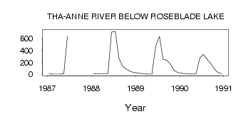
| PointID: | 3528 | Code: | 06HE001 | Latitude (decimal degrees): | 61.00 | Longitude (decimal degrees): | -97.02 | Drainage Area (km2): | Source: | Hydat | Hydrological Zone: | Northwest Hudson Bay | Name: | THA-ANNE RIVER BELOW ROSEBLADE LAKE |
|---|
| Download | |
|---|---|
| Site Descriptor Information | Site Time Series Data |
| Link to all available data | |
| ID | Year | Jan | Feb | Mar | Apr | May | Jun | Jul | Aug | Sep | Oct | Nov | Dec |
|---|---|---|---|---|---|---|---|---|---|---|---|---|---|
| 3528 | 1987 | 4.00 | 3.00 | 3.00 | 3.00 | 3.52 | 641.00 | ||||||
| 3528 | 1988 | 9.00 | 7.00 | 5.00 | 4.00 | 4.14 | 708.00 | 721.00 | 271.00 | 129.00 | 87.80 | 48.00 | 31.00 |
| 3528 | 1989 | 20.00 | 12.00 | 5.00 | 1.00 | 0.88 | 474.00 | 637.00 | 248.00 | 237.00 | 168.00 | 64.00 | 28.00 |
| 3528 | 1990 | 15.00 | 8.00 | 5.00 | 3.00 | 4.08 | 274.00 | 331.00 | 248.00 | 176.00 | 85.90 | 24.00 | 11.00 |
 Return to R-Arctic Net Home Page