| PointID: | 3527 | Code: | 06HD002 | Latitude (decimal degrees): | 61.13 | Longitude (decimal degrees): | -97.12 | Drainage Area (km2): | 7140.00 | Source: | Hydat | Hydrological Zone: | Northwest Hudson Bay | Name: | THA-ANNE RIVER BELOW SOUTH HENIK LAKE |
|---|
| Download | |
|---|---|
| Site Descriptor Information | Site Time Series Data |
| Link to all available data | |
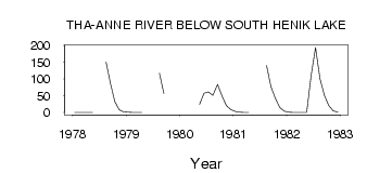
| ID | Year | Jan | Feb | Mar | Apr | May | Jun | Jul | Aug | Sep | Oct | Nov | Dec |
|---|---|---|---|---|---|---|---|---|---|---|---|---|---|
| 3527 | 1978 | 0.00 | 0.00 | 0.00 | 0.00 | 0.00 | 151.00 | 87.30 | 31.70 | 8.00 | 2.00 | ||
| 3527 | 1979 | 1.00 | 0.00 | 0.00 | 0.00 | 117.00 | 56.90 | ||||||
| 3527 | 1980 | 23.90 | 57.20 | 61.50 | 51.60 | 83.50 | 49.90 | 20.00 | 9.00 | ||||
| 3527 | 1981 | 3.00 | 1.00 | 0.00 | 0.00 | 140.00 | 77.10 | 42.20 | 15.00 | 4.00 | |||
| 3527 | 1982 | 1.00 | 0.00 | 0.00 | 0.00 | 0.48 | 110.00 | 194.00 | 101.00 | 51.00 | 20.10 | 5.00 | 1.00 |
 Return to R-Arctic Net Home Page