| PointID: | 3526 | Code: | 06HD001 | Latitude (decimal degrees): | 61.25 | Longitude (decimal degrees): | -98.47 | Drainage Area (km2): | 6900.00 | Source: | Hydat | Hydrological Zone: | Northwest Hudson Bay | Name: | KOGNAK RIVER BELOW MOUNTAIN LAKE |
|---|
| Download | |
|---|---|
| Site Descriptor Information | Site Time Series Data |
| Link to all available data | |
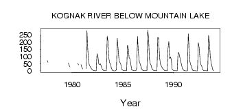
| ID | Year | Jan | Feb | Mar | Apr | May | Jun | Jul | Aug | Sep | Oct | Nov | Dec |
|---|---|---|---|---|---|---|---|---|---|---|---|---|---|
| 3526 | 1977 | 71.70 | 59.10 | ||||||||||
| 3526 | 1979 | 53.70 | 37.50 | 27.60 | |||||||||
| 3526 | 1980 | 52.40 | 42.20 | 44.00 | 24.00 | ||||||||
| 3526 | 1981 | 14.00 | 16.80 | 280.00 | 152.00 | 63.00 | 39.30 | 30.10 | 17.00 | 10.00 | |||
| 3526 | 1982 | 5.00 | 3.00 | 1.00 | 0.00 | 0.56 | 120.00 | 96.30 | 48.10 | 44.70 | 49.40 | 31.00 | 15.00 |
| 3526 | 1983 | 7.00 | 3.00 | 2.00 | 1.00 | 1.69 | 241.00 | 202.00 | 89.30 | 54.90 | 48.90 | 20.00 | 5.00 |
| 3526 | 1984 | 2.00 | 0.00 | 0.00 | 0.00 | 9.80 | 227.00 | 140.00 | 71.10 | 59.60 | 47.60 | 14.00 | 7.00 |
| 3526 | 1985 | 4.00 | 3.00 | 2.00 | 1.00 | 0.53 | 179.00 | 160.00 | 92.40 | 83.40 | 50.20 | 9.00 | 5.00 |
| 3526 | 1986 | 3.00 | 2.00 | 2.00 | 1.00 | 18.30 | 239.00 | 130.00 | 63.60 | 49.00 | 28.70 | 12.00 | 5.00 |
| 3526 | 1987 | 3.00 | 2.00 | 1.00 | 1.00 | 1.85 | 285.00 | 230.00 | 86.60 | 52.00 | 39.80 | 17.00 | 7.00 |
| 3526 | 1988 | 4.00 | 2.00 | 1.00 | 0.00 | 0.99 | 233.00 | 229.00 | 92.20 | 48.50 | 35.10 | 24.00 | 15.00 |
| 3526 | 1989 | 8.00 | 4.00 | 2.00 | 1.00 | 0.31 | 155.00 | 205.00 | 86.20 | 95.50 | 78.70 | 13.00 | 5.00 |
| 3526 | 1990 | 3.00 | 2.00 | 1.00 | 0.00 | 1.49 | 127.00 | 124.00 | 93.30 | 66.40 | 44.00 | 18.00 | 8.00 |
| 3526 | 1991 | 3.00 | 2.00 | 0.00 | 0.00 | 0.69 | 259.00 | 161.00 | 65.30 | 41.10 | 34.90 | 6.00 | 1.00 |
| 3526 | 1992 | 1.00 | 1.00 | 0.00 | 0.00 | 0.85 | 196.00 | 163.00 | 70.60 | 42.50 | 31.60 | 9.00 | 4.00 |
| 3526 | 1993 | 2.00 | 2.00 | 1.00 | 0.00 | 0.27 | 247.00 | 210.00 | 109.00 | 60.30 | 36.20 | 10.00 | 1.00 |
 Return to R-Arctic Net Home Page