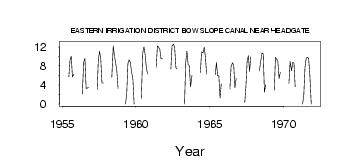
| PointID: | 344 | Code: | 05BN005 | Latitude (decimal degrees): | 50.50 | Longitude (decimal degrees): | -112.14 | Drainage Area (km2): | Source: | Hydat | Hydrological Zone: | Nelson | Name: | EASTERN IRRIGATION DISTRICT BOW SLOPE CANAL NEAR HEADGATE |
|---|
| Download | |
|---|---|
| Site Descriptor Information | Site Time Series Data |
| Link to all available data | |
| ID | Year | Jan | Feb | Mar | Apr | May | Jun | Jul | Aug | Sep | Oct | Nov | Dec |
|---|---|---|---|---|---|---|---|---|---|---|---|---|---|
| 344 | 1955 | 5.72 | 9.26 | 10.00 | 5.72 | 6.26 | |||||||
| 344 | 1956 | 2.12 | 8.74 | 9.57 | 3.28 | 3.33 | 3.56 | ||||||
| 344 | 1957 | 3.05 | 9.31 | 11.10 | 9.42 | 4.42 | 4.44 | ||||||
| 344 | 1958 | 5.58 | 12.20 | 10.10 | 8.58 | 6.90 | 3.27 | ||||||
| 344 | 1959 | 0.00 | 1.99 | 8.48 | 9.29 | 8.71 | 6.87 | 5.07 | 0.00 | ||||
| 344 | 1960 | 1.22 | 10.70 | 12.00 | 10.30 | 7.62 | 6.29 | ||||||
| 344 | 1961 | 7.69 | 12.20 | 11.90 | 11.50 | 9.50 | 9.46 | ||||||
| 344 | 1962 | 7.35 | 12.20 | 12.60 | 11.80 | 7.65 | 7.34 | ||||||
| 344 | 1963 | 0.00 | 8.76 | 11.10 | 8.26 | 8.01 | 3.57 | 6.01 | |||||
| 344 | 1964 | 6.62 | 10.90 | 10.70 | 11.90 | 9.86 | 6.25 | ||||||
| 344 | 1965 | 6.14 | 8.70 | 5.92 | 5.95 | 1.28 | 4.26 | ||||||
| 344 | 1966 | 3.11 | 7.91 | 8.68 | 8.06 | 3.42 | 5.33 | ||||||
| 344 | 1967 | 0.31 | 3.87 | 9.08 | 10.10 | 6.85 | 9.94 | ||||||
| 344 | 1968 | 6.94 | 8.88 | 10.70 | 10.50 | 2.46 | 4.06 | ||||||
| 344 | 1969 | 2.87 | 9.82 | 9.42 | 8.88 | 5.35 | 6.67 | ||||||
| 344 | 1970 | 4.28 | 8.89 | 6.98 | 8.75 | 8.56 | 3.64 | ||||||
| 344 | 1971 | 0.00 | 1.96 | 7.72 | 9.65 | 9.79 | 9.61 | 6.27 | 0.00 |
 Return to R-Arctic Net Home Page