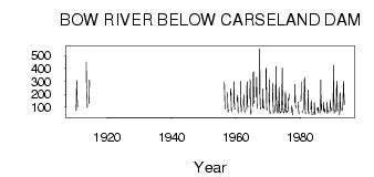
| PointID: | 324 | Code: | 05BM002 | Latitude (decimal degrees): | 50.82 | Longitude (decimal degrees): | -113.44 | Drainage Area (km2): | 15700.00 | Source: | Hydat | Hydrological Zone: | Nelson | Name: | BOW RIVER BELOW CARSELAND DAM |
|---|
| Download | |
|---|---|
| Site Descriptor Information | Site Time Series Data |
| Link to all available data | |
| ID | Year | Jan | Feb | Mar | Apr | May | Jun | Jul | Aug | Sep | Oct | Nov | Dec |
|---|---|---|---|---|---|---|---|---|---|---|---|---|---|
| 324 | 1910 | 73.00 | 203.00 | 307.00 | 224.00 | 153.00 | 111.00 | 102.00 | |||||
| 324 | 1913 | 451.00 | 271.00 | 248.00 | 162.00 | 97.60 | |||||||
| 324 | 1914 | 130.00 | 310.00 | 254.00 | |||||||||
| 324 | 1956 | 294.00 | 209.00 | 126.00 | 95.50 | 86.90 | |||||||
| 324 | 1957 | 216.00 | 196.00 | 99.00 | 60.40 | 76.20 | 79.10 | ||||||
| 324 | 1958 | 191.00 | 242.00 | 239.00 | 109.00 | 62.90 | 83.90 | ||||||
| 324 | 1959 | 131.00 | 299.00 | 199.00 | 102.00 | 84.60 | 87.50 | ||||||
| 324 | 1960 | 145.00 | 194.00 | 187.00 | 113.00 | 55.10 | 55.70 | ||||||
| 324 | 1961 | 194.00 | 300.00 | 110.00 | 112.00 | 64.10 | 111.00 | ||||||
| 324 | 1962 | 119.00 | 197.00 | 125.00 | 96.70 | 87.20 | 58.60 | ||||||
| 324 | 1963 | 78.80 | 265.00 | 295.00 | 131.00 | 106.00 | 97.70 | ||||||
| 324 | 1964 | 169.00 | 315.00 | 189.00 | 70.70 | 42.10 | 78.70 | ||||||
| 324 | 1965 | 103.00 | 369.00 | 374.00 | 180.00 | 130.00 | 147.00 | ||||||
| 324 | 1966 | 181.00 | 334.00 | 261.00 | 127.00 | 89.90 | 89.40 | ||||||
| 324 | 1967 | 201.00 | 554.00 | 233.00 | 119.00 | 92.70 | 84.70 | ||||||
| 324 | 1968 | 91.70 | 243.00 | 156.00 | 109.00 | 88.60 | 107.00 | ||||||
| 324 | 1969 | 237.00 | 406.00 | 385.00 | 129.00 | 77.20 | 76.60 | ||||||
| 324 | 1970 | 139.00 | 314.00 | 149.00 | 77.90 | 47.90 | 63.70 | ||||||
| 324 | 1971 | 157.00 | 286.00 | 131.00 | 107.00 | 53.90 | 54.60 | ||||||
| 324 | 1972 | 63.00 | 72.00 | 172.00 | 416.00 | 277.00 | 181.00 | 122.00 | 94.90 | 73.00 | 68.00 | ||
| 324 | 1973 | 54.00 | 64.00 | 78.00 | 77.00 | 159.00 | 254.00 | 166.00 | 83.40 | 65.90 | 54.50 | 61.00 | 58.00 |
| 324 | 1974 | 61.00 | 63.00 | 75.00 | 122.00 | 208.00 | 403.00 | 220.00 | 143.00 | 89.70 | 68.20 | 54.00 | 63.00 |
| 324 | 1975 | 59.00 | 66.00 | 72.00 | 89.00 | 133.00 | 219.00 | 170.00 | 83.50 | 62.90 | 58.30 | 58.00 | 61.00 |
| 324 | 1976 | 69.00 | 67.00 | 71.00 | 79.00 | 168.00 | 155.00 | 161.00 | 203.00 | 56.60 | |||
| 324 | 1977 | 58.80 | 110.00 | 76.40 | 83.00 | 62.00 | 38.90 | ||||||
| 324 | 1978 | 137.00 | 277.00 | 183.00 | 105.00 | 108.00 | 93.60 | ||||||
| 324 | 1979 | 140.00 | 134.00 | 81.10 | 64.70 | 51.80 | 47.60 | ||||||
| 324 | 1980 | 145.00 | 164.00 | 297.00 | 59.00 | 73.40 | |||||||
| 324 | 1981 | 80.00 | 273.00 | 332.00 | 291.00 | 201.00 | 66.40 | 47.30 | |||||
| 324 | 1982 | 73.50 | 233.00 | 155.00 | 57.10 | 47.70 | 56.80 | ||||||
| 324 | 1983 | 83.00 | 94.20 | 149.00 | 121.00 | 73.40 | 51.40 | 41.40 | |||||
| 324 | 1984 | 53.00 | 42.50 | 136.00 | 93.40 | 61.40 | 53.10 | 42.20 | |||||
| 324 | 1985 | 79.00 | 86.60 | 95.60 | 79.20 | 68.20 | 98.70 | 53.50 | |||||
| 324 | 1986 | 56.00 | 129.00 | 311.00 | 151.00 | 73.40 | 93.10 | 120.00 | |||||
| 324 | 1987 | 67.00 | 140.00 | 82.00 | 83.10 | 69.20 | 85.80 | 58.00 | |||||
| 324 | 1988 | 50.00 | 69.90 | 137.00 | 93.00 | 79.50 | 69.80 | 54.10 | |||||
| 324 | 1989 | 62.00 | 80.50 | 154.00 | 93.90 | 90.40 | 94.00 | 71.90 | |||||
| 324 | 1990 | 72.00 | 193.00 | 424.00 | 238.00 | 128.00 | 52.70 | 73.00 | |||||
| 324 | 1991 | 66.00 | 179.00 | 300.00 | 287.00 | 152.00 | 73.90 | 71.70 | |||||
| 324 | 1992 | 38.00 | 63.90 | 204.00 | 212.00 | 105.00 | 71.00 | 94.50 | |||||
| 324 | 1993 | 76.00 | 152.00 | 246.00 | 302.00 | 215.00 | 165.00 | 121.00 |
 Return to R-Arctic Net Home Page