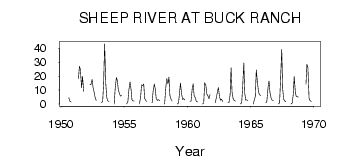
| PointID: | 315 | Code: | 05BL018 | Latitude (decimal degrees): | 50.62 | Longitude (decimal degrees): | -114.42 | Drainage Area (km2): | 454.00 | Source: | Hydat | Hydrological Zone: | Nelson | Name: | SHEEP RIVER AT BUCK RANCH |
|---|
| Download | |
|---|---|
| Site Descriptor Information | Site Time Series Data |
| Link to all available data | |
| ID | Year | Jan | Feb | Mar | Apr | May | Jun | Jul | Aug | Sep | Oct | Nov | Dec |
|---|---|---|---|---|---|---|---|---|---|---|---|---|---|
| 315 | 1950 | 4.52 | 2.10 | 1.64 | |||||||||
| 315 | 1951 | 18.10 | 27.20 | 24.90 | 11.70 | 19.80 | 8.97 | ||||||
| 315 | 1952 | 14.00 | 13.90 | 17.70 | 11.80 | 8.93 | 4.40 | 2.57 | |||||
| 315 | 1953 | 1.00 | 2.00 | 15.10 | 43.20 | 14.40 | 4.73 | 2.31 | 1.92 | ||||
| 315 | 1954 | 0.00 | 11.00 | 19.10 | 17.00 | 10.40 | 7.50 | 5.76 | 6.11 | ||||
| 315 | 1955 | 0.00 | 2.00 | 10.00 | 15.90 | 10.90 | 2.93 | 2.09 | 2.20 | ||||
| 315 | 1956 | 0.00 | 5.00 | 13.90 | 13.10 | 14.30 | 4.04 | 2.68 | 1.82 | ||||
| 315 | 1957 | 1.00 | 9.00 | 14.40 | 11.10 | 3.99 | 2.62 | 3.21 | 2.44 | ||||
| 315 | 1958 | 0.00 | 12.00 | 18.40 | 14.50 | 19.40 | 6.27 | 3.25 | 2.22 | ||||
| 315 | 1959 | 0.00 | 1.00 | 7.64 | 15.00 | 7.06 | 3.40 | 3.96 | 2.96 | ||||
| 315 | 1960 | 2.00 | 2.00 | 11.00 | 14.50 | 6.09 | 4.61 | 1.97 | 1.54 | ||||
| 315 | 1961 | 0.00 | 1.00 | 15.20 | 13.30 | 7.18 | 6.06 | 3.88 | 6.83 | ||||
| 315 | 1962 | 1.00 | 5.00 | 8.46 | 12.00 | 5.04 | 2.83 | 3.43 | 1.98 | ||||
| 315 | 1963 | 1.00 | 1.00 | 6.83 | 26.00 | 8.68 | 3.52 | 2.66 | 2.11 | ||||
| 315 | 1964 | 0.00 | 1.00 | 11.20 | 29.60 | 7.76 | 2.89 | 2.93 | 2.68 | ||||
| 315 | 1965 | 0.00 | 3.00 | 5.63 | 24.50 | 15.30 | 8.99 | 6.79 | 6.22 | ||||
| 315 | 1966 | 1.00 | 2.00 | 11.90 | 16.60 | 8.18 | 4.15 | 2.74 | 2.50 | ||||
| 315 | 1967 | 0.00 | 1.00 | 16.90 | 39.30 | 11.00 | 3.45 | 2.38 | 1.64 | ||||
| 315 | 1968 | 0.00 | 1.00 | 6.89 | 19.90 | 7.81 | 5.14 | 5.14 | 4.98 | ||||
| 315 | 1969 | 14.20 | 28.50 | 26.30 | 3.97 | 2.49 | 1.88 |
 Return to R-Arctic Net Home Page