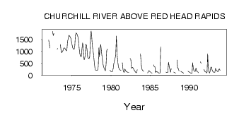
| PointID: | 3131 | Code: | 06FD001 | Latitude (decimal degrees): | 58.12 | Longitude (decimal degrees): | -94.62 | Drainage Area (km2): | 287000.00 | Source: | Hydat | Hydrological Zone: | Northwest Hudson Bay | Name: | CHURCHILL RIVER ABOVE RED HEAD RAPIDS |
|---|
| Download | |
|---|---|
| Site Descriptor Information | Site Time Series Data |
| Link to all available data | |
| ID | Year | Jan | Feb | Mar | Apr | May | Jun | Jul | Aug | Sep | Oct | Nov | Dec |
|---|---|---|---|---|---|---|---|---|---|---|---|---|---|
| 3131 | 1972 | 1480.00 | 1300.00 | 1140.00 | 1840.00 | 1670.00 | 1750.00 | ||||||
| 3131 | 1973 | 1100.00 | 1120.00 | 1300.00 | 1030.00 | 942.00 | 1010.00 | 1030.00 | 1130.00 | ||||
| 3131 | 1974 | 1150.00 | 1130.00 | 1070.00 | 1020.00 | 1120.00 | 1420.00 | 1520.00 | 1680.00 | 1650.00 | 1610.00 | 1540.00 | 1420.00 |
| 3131 | 1975 | 1270.00 | 1150.00 | 1090.00 | 1090.00 | 1240.00 | 1640.00 | 1780.00 | 1760.00 | 1690.00 | 1590.00 | 1390.00 | 1100.00 |
| 3131 | 1976 | 885.00 | 791.00 | 775.00 | 1110.00 | 1360.00 | 1230.00 | 672.00 | 657.00 | 832.00 | 1300.00 | 1250.00 | 1080.00 |
| 3131 | 1977 | 750.00 | 717.00 | 702.00 | 789.00 | 1570.00 | 1860.00 | 1690.00 | 1250.00 | 1050.00 | 838.00 | 499.00 | 277.00 |
| 3131 | 1978 | 208.00 | 206.00 | 203.00 | 206.00 | 354.00 | 1150.00 | 780.00 | 1140.00 | 1290.00 | 1000.00 | 747.00 | 512.00 |
| 3131 | 1979 | 400.00 | 309.00 | 237.00 | 186.00 | 430.00 | 1030.00 | 1110.00 | 212.00 | 163.00 | |||
| 3131 | 1980 | 149.00 | 152.00 | 158.00 | 274.00 | 491.00 | 620.00 | 733.00 | 821.00 | 1650.00 | 888.00 | 582.00 | 345.00 |
| 3131 | 1981 | 288.00 | 226.00 | 212.00 | 204.00 | 525.00 | 235.00 | 151.00 | 117.00 | 260.00 | 204.00 | 151.00 | |
| 3131 | 1982 | 137.00 | 130.00 | 124.00 | 119.00 | 701.00 | 655.00 | 285.00 | 309.00 | 328.00 | 277.00 | 220.00 | |
| 3131 | 1983 | 178.00 | 134.00 | 105.00 | 99.00 | 229.00 | 327.00 | 903.00 | 463.00 | 265.00 | |||
| 3131 | 1984 | 201.00 | 177.00 | 157.00 | 91.90 | 151.00 | 197.00 | 157.00 | |||||
| 3131 | 1985 | 134.00 | 105.00 | 96.00 | 86.00 | 436.00 | 355.00 | 349.00 | 107.00 | 160.00 | 150.00 | 132.00 | |
| 3131 | 1986 | 122.00 | 89.00 | 77.00 | 86.00 | 1190.00 | |||||||
| 3131 | 1987 | 130.00 | 113.00 | 110.00 | 124.00 | 543.00 | 376.00 | 243.00 | 125.00 | 271.00 | |||
| 3131 | 1988 | 127.00 | 117.00 | 96.00 | 97.00 | 633.00 | 288.00 | 279.00 | 182.00 | 161.00 | |||
| 3131 | 1989 | 150.00 | 110.00 | 106.00 | 78.00 | 168.00 | 143.00 | ||||||
| 3131 | 1990 | 128.00 | 110.00 | 87.00 | 70.00 | 83.40 | 525.00 | 313.00 | 182.00 | 160.00 | 163.00 | 303.00 | 207.00 |
| 3131 | 1991 | 147.00 | 137.00 | 101.00 | 565.00 | 501.00 | 247.00 | 198.00 | |||||
| 3131 | 1992 | 151.00 | 140.00 | 116.00 | 86.00 | 898.00 | 367.00 | 154.00 | 86.20 | 179.00 | 341.00 | 322.00 | 224.00 |
| 3131 | 1993 | 160.00 | 130.00 | 117.00 | 115.00 | 288.00 | 202.00 | 202.00 | 158.00 | 154.00 | 234.00 | 263.00 | 204.00 |
 Return to R-Arctic Net Home Page