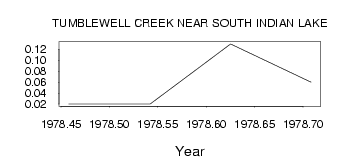
| PointID: | 3126 | Code: | 06EC004 | Latitude (decimal degrees): | 56.77 | Longitude (decimal degrees): | -99.11 | Drainage Area (km2): | 4.34 | Source: | Hydat | Hydrological Zone: | Northwest Hudson Bay | Name: | TUMBLEWELL CREEK NEAR SOUTH INDIAN LAKE |
|---|
| Download | |
|---|---|
| Site Descriptor Information | Site Time Series Data |
| Link to all available data | |
| ID | Year | Jan | Feb | Mar | Apr | May | Jun | Jul | Aug | Sep | Oct | Nov | Dec |
|---|---|---|---|---|---|---|---|---|---|---|---|---|---|
| 3126 | 1978 | 0.02 | 0.02 | 0.13 | 0.06 |
 Return to R-Arctic Net Home Page