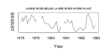
| PointID: | 3124 | Code: | 06EB005 | Latitude (decimal degrees): | 56.22 | Longitude (decimal degrees): | -101.00 | Drainage Area (km2): | 3840.00 | Source: | Hydat | Hydrological Zone: | Northwest Hudson Bay | Name: | LAURIE RIVER BELOW LAURIE RIVER HYDRO PLANT |
|---|
| Download | |
|---|---|
| Site Descriptor Information | Site Time Series Data |
| Link to all available data | |
| ID | Year | Jan | Feb | Mar | Apr | May | Jun | Jul | Aug | Sep | Oct | Nov | Dec |
|---|---|---|---|---|---|---|---|---|---|---|---|---|---|
| 3124 | 1978 | 27.00 | 34.00 | 28.00 | 35.00 | 37.10 | 24.10 | 30.60 | 30.40 | 37.70 | 36.10 | 34.00 | 28.00 |
| 3124 | 1979 | 30.00 | 33.20 | 36.10 | 27.20 | 25.10 | 25.00 | 23.70 | 24.00 | 19.00 | |||
| 3124 | 1980 | 17.00 | 18.00 | 19.00 | 24.00 | 28.10 | 13.90 | 11.80 | 19.50 | 28.00 | 25.00 | ||
| 3124 | 1981 | 27.00 | 31.00 | 27.00 | 25.00 | 29.40 | 19.40 | 14.80 | 12.80 | 12.60 | 15.80 | 17.00 | 18.00 |
| 3124 | 1982 | 17.00 | 14.00 | 16.00 | 19.00 | 35.80 | 40.30 | 34.70 | 33.30 | 24.60 | 16.70 | 21.00 | 21.00 |
 Return to R-Arctic Net Home Page