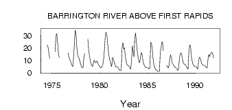
| PointID: | 3122 | Code: | 06EB003 | Latitude (decimal degrees): | 56.76 | Longitude (decimal degrees): | -99.97 | Drainage Area (km2): | 1770.00 | Source: | Hydat | Hydrological Zone: | Northwest Hudson Bay | Name: | BARRINGTON RIVER ABOVE FIRST RAPIDS |
|---|
| Download | |
|---|---|
| Site Descriptor Information | Site Time Series Data |
| Link to all available data | |
| ID | Year | Jan | Feb | Mar | Apr | May | Jun | Jul | Aug | Sep | Oct | Nov | Dec |
|---|---|---|---|---|---|---|---|---|---|---|---|---|---|
| 3122 | 1974 | 22.40 | 20.50 | 15.60 | 11.60 | ||||||||
| 3122 | 1975 | 17.20 | 30.10 | 31.60 | 24.50 | 15.40 | 12.30 | ||||||
| 3122 | 1976 | 16.00 | 13.50 | 11.00 | 10.00 | ||||||||
| 3122 | 1977 | 8.00 | 6.00 | 5.00 | 11.00 | 22.00 | 34.50 | 32.40 | 21.40 | 15.30 | 12.90 | 12.00 | 9.00 |
| 3122 | 1978 | 7.00 | 5.00 | 4.00 | 4.00 | 12.30 | 15.60 | 27.40 | 19.00 | 14.00 | |||
| 3122 | 1979 | 10.00 | 7.00 | 6.00 | 5.00 | 7.73 | 10.30 | 8.66 | 8.23 | 9.44 | 8.92 | 7.00 | 6.00 |
| 3122 | 1980 | 5.00 | 4.00 | 4.00 | 5.00 | 7.06 | 12.00 | 20.30 | 31.70 | 32.70 | 31.00 | 23.00 | 16.00 |
| 3122 | 1981 | 12.00 | 9.00 | 7.00 | 5.00 | 12.40 | 11.10 | 8.90 | 6.92 | 4.78 | 5.08 | 5.00 | 4.00 |
| 3122 | 1982 | 3.00 | 2.00 | 2.00 | 2.00 | 19.90 | 24.40 | 19.20 | 20.30 | 14.10 | 9.74 | 7.00 | 6.00 |
| 3122 | 1983 | 6.00 | 5.00 | 4.00 | 3.00 | 11.10 | 21.80 | 16.50 | 13.10 | 27.70 | 32.20 | 25.00 | 18.00 |
| 3122 | 1984 | 13.00 | 10.00 | 8.00 | 11.00 | 16.40 | 15.50 | 10.60 | 7.53 | 6.32 | 4.74 | 4.00 | 4.00 |
| 3122 | 1985 | 4.00 | 4.00 | 3.00 | 4.00 | 24.80 | 23.80 | 18.70 | 11.90 | 6.56 | 4.23 | 3.00 | 2.00 |
| 3122 | 1986 | 2.00 | 1.00 | 1.00 | 1.00 | 16.50 | 20.20 | 25.00 | 24.90 | 17.70 | |||
| 3122 | 1987 | 6.00 | 5.00 | 4.00 | 6.00 | 12.20 | 14.60 | 12.00 | 8.01 | 7.12 | 5.91 | 5.00 | 4.00 |
| 3122 | 1988 | 4.00 | 3.00 | 2.00 | 3.00 | 11.00 | 15.10 | 16.10 | 15.00 | 10.90 | 7.91 | 7.00 | 7.00 |
| 3122 | 1989 | 6.00 | 5.00 | 4.00 | 3.00 | 17.80 | 22.50 | 21.30 | 14.10 | 9.87 | 7.07 | 6.00 | 5.00 |
| 3122 | 1990 | 5.00 | 5.00 | 4.00 | 3.00 | 8.89 | 12.40 | 12.50 | 10.20 | 7.42 | 6.75 | 6.00 | 6.00 |
| 3122 | 1991 | 6.00 | 5.00 | 4.00 | 4.00 | 11.40 | 14.80 | 13.10 | 14.90 | 16.30 | 16.60 | 15.00 | 12.00 |
 Return to R-Arctic Net Home Page