| PointID: | 3114 | Code: | 05UF006 | Latitude (decimal degrees): | 56.38 | Longitude (decimal degrees): | -94.63 | Drainage Area (km2): | Source: | Hydat | Hydrological Zone: | Nelson | Name: | NELSON RIVER AT KETTLE GENERATING STATION |
|---|
| Download | |
|---|---|
| Site Descriptor Information | Site Time Series Data |
| Link to all available data | |
| ID | Year | Jan | Feb | Mar | Apr | May | Jun | Jul | Aug | Sep | Oct | Nov | Dec |
|---|---|---|---|---|---|---|---|---|---|---|---|---|---|
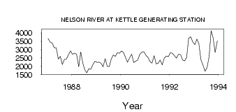
| 3114 | 1987 | 3660.00 | 3450.00 | 3400.00 | 3120.00 | 3100.00 | 2420.00 | 2590.00 | 2100.00 | 2400.00 | 2440.00 | 2690.00 | 2920.00 |
| 3114 | 1988 | 2710.00 | 2780.00 | 2720.00 | 1970.00 | 2850.00 | 2200.00 | 1780.00 | 1600.00 | 1850.00 | 1820.00 | 2110.00 | 2300.00 |
| 3114 | 1989 | 2230.00 | 2240.00 | 2180.00 | 1970.00 | 2450.00 | 1990.00 | 1980.00 | 2430.00 | 2670.00 | 2590.00 | 2810.00 | 2770.00 |
| 3114 | 1990 | 2920.00 | 2820.00 | 2530.00 | 2240.00 | 2510.00 | 2720.00 | 2220.00 | 2300.00 | 2370.00 | 2700.00 | 2850.00 | 2860.00 |
| 3114 | 1991 | 2650.00 | 2530.00 | 2290.00 | 2180.00 | 2630.00 | 2140.00 | 2180.00 | 2370.00 | 2080.00 | 2470.00 | 2610.00 | 2570.00 |
| 3114 | 1992 | 2810.00 | 2770.00 | 2630.00 | 2480.00 | 2710.00 | 2690.00 | 2370.00 | 2320.00 | 2530.00 | 3680.00 | 3760.00 | 3450.00 |
| 3114 | 1993 | 3300.00 | 3630.00 | 3350.00 | 2390.00 | 2080.00 | 1690.00 | 1930.00 | 2570.00 | 4130.00 | 3700.00 | 2820.00 | 3520.00 |
 Return to R-Arctic Net Home Page