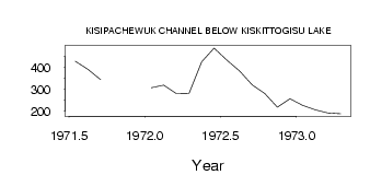
| PointID: | 3109 | Code: | 05UB012 | Latitude (decimal degrees): | 54.26 | Longitude (decimal degrees): | -98.28 | Drainage Area (km2): | Source: | Hydat | Hydrological Zone: | Nelson | Name: | KISIPACHEWUK CHANNEL BELOW KISKITTOGISU LAKE |
|---|
| Download | |
|---|---|
| Site Descriptor Information | Site Time Series Data |
| Link to all available data | |
| ID | Year | Jan | Feb | Mar | Apr | May | Jun | Jul | Aug | Sep | Oct | Nov | Dec |
|---|---|---|---|---|---|---|---|---|---|---|---|---|---|
| 3109 | 1971 | 427.00 | 390.00 | 344.00 | |||||||||
| 3109 | 1972 | 306.00 | 319.00 | 280.00 | 281.00 | 424.00 | 487.00 | 432.00 | 383.00 | 320.00 | 280.00 | 218.00 | 256.00 |
| 3109 | 1973 | 226.00 | 206.00 | 192.00 | 188.00 |
 Return to R-Arctic Net Home Page