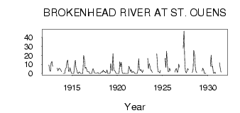
| PointID: | 3086 | Code: | 05SA001 | Latitude (decimal degrees): | 50.05 | Longitude (decimal degrees): | -96.44 | Drainage Area (km2): | 1540.00 | Source: | Hydat | Hydrological Zone: | Nelson | Name: | BROKENHEAD RIVER AT ST. OUENS |
|---|
| Download | |
|---|---|
| Site Descriptor Information | Site Time Series Data |
| Link to all available data | |
| ID | Year | Jan | Feb | Mar | Apr | May | Jun | Jul | Aug | Sep | Oct | Nov | Dec |
|---|---|---|---|---|---|---|---|---|---|---|---|---|---|
| 3086 | 1912 | 9.59 | 3.60 | 2.30 | 11.70 | 13.50 | 8.00 | ||||||
| 3086 | 1913 | 5.95 | 3.04 | 5.37 | 5.69 | 4.88 | 3.46 | 2.00 | |||||
| 3086 | 1914 | 0.00 | 0.00 | 0.00 | 5.00 | 6.70 | 13.40 | 15.00 | 2.43 | 2.39 | 6.42 | 3.00 | 0.00 |
| 3086 | 1915 | 0.00 | 0.00 | 0.00 | 10.00 | 14.80 | 6.44 | 3.60 | 0.40 | 0.12 | 1.84 | 1.00 | 0.00 |
| 3086 | 1916 | 0.00 | 0.00 | 0.00 | 20.00 | 16.90 | 5.79 | 6.87 | 5.14 | 1.88 | 2.10 | 2.00 | 0.00 |
| 3086 | 1917 | 0.00 | 0.00 | 0.00 | 5.00 | 5.08 | 1.07 | 0.60 | 0.60 | 0.69 | 0.68 | 1.00 | 0.00 |
| 3086 | 1918 | 0.00 | 0.00 | 1.00 | 2.00 | 1.33 | 3.88 | 1.75 | 2.07 | 0.79 | 1.28 | 4.00 | 0.00 |
| 3086 | 1919 | 0.00 | 0.00 | 0.00 | 11.00 | 4.71 | 2.89 | 22.10 | 3.40 | 3.37 | 2.16 | 0.00 | 0.00 |
| 3086 | 1920 | 0.00 | 0.00 | 0.00 | 13.00 | 7.40 | 12.50 | 1.41 | 0.06 | 0.11 | 0.16 | 0.00 | 0.00 |
| 3086 | 1921 | 0.00 | 0.00 | 0.00 | 8.00 | 6.26 | 2.24 | 4.21 | 1.04 | 1.95 | 2.19 | 1.00 | 0.00 |
| 3086 | 1922 | 0.00 | 0.00 | 0.00 | 4.00 | 16.40 | 5.28 | 3.22 | 4.43 | 2.79 | 0.98 | 4.00 | |
| 3086 | 1923 | 16.80 | 5.34 | 11.20 | 8.23 | 3.64 | 3.53 | 1.00 | |||||
| 3086 | 1924 | 22.20 | 6.13 | 1.79 | 1.67 | 0.60 | 3.59 | ||||||
| 3086 | 1925 | 17.00 | 6.58 | 24.80 | 9.70 | 2.00 | 1.98 | 5.88 | 3.00 | ||||
| 3086 | 1926 | 1.35 | 4.52 | 5.54 | 1.47 | 1.79 | 10.40 | 7.00 | |||||
| 3086 | 1927 | 28.00 | 47.30 | 14.70 | 2.70 | 0.57 | 2.56 | 5.53 | 4.00 | ||||
| 3086 | 1928 | 1.00 | 4.11 | 25.80 | 21.10 | 7.63 | 2.56 | 0.75 | |||||
| 3086 | 1929 | 2.68 | 5.93 | 3.98 | 0.28 | 0.13 | 0.23 | ||||||
| 3086 | 1930 | 8.00 | 20.50 | 7.35 | 7.97 | 0.77 | 0.26 | 1.61 | 0.00 | ||||
| 3086 | 1931 | 12.00 | 6.39 | 1.37 |
 Return to R-Arctic Net Home Page