| PointID: | 3085 | Code: | 05RE001 | Latitude (decimal degrees): | 52.77 | Longitude (decimal degrees): | -96.75 | Drainage Area (km2): | 6850.00 | Source: | Hydat | Hydrological Zone: | Nelson | Name: | POPLAR RIVER AT OUTLET OF WEAVER LAKE |
|---|
| Download | |
|---|---|
| Site Descriptor Information | Site Time Series Data |
| Link to all available data | |
| ID | Year | Jan | Feb | Mar | Apr | May | Jun | Jul | Aug | Sep | Oct | Nov | Dec |
|---|---|---|---|---|---|---|---|---|---|---|---|---|---|
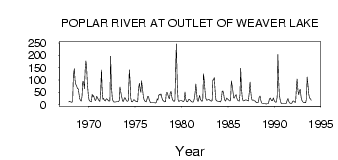
| 3085 | 1967 | 11.00 | 13.00 | ||||||||||
| 3085 | 1968 | 11.00 | 10.00 | 9.00 | 17.00 | 122.00 | 145.00 | 98.10 | 82.60 | 76.30 | 64.90 | 65.00 | 45.00 |
| 3085 | 1969 | 25.00 | 18.00 | 14.00 | 34.00 | 94.00 | 92.50 | 64.30 | 141.00 | 177.00 | 153.00 | 88.00 | 39.00 |
| 3085 | 1970 | 19.00 | 15.00 | 13.00 | 11.00 | 41.30 | 32.80 | 35.90 | 26.70 | 16.20 | 20.30 | 33.00 | 29.00 |
| 3085 | 1971 | 21.00 | 16.00 | 13.00 | 35.00 | 141.00 | 53.70 | 22.00 | 25.00 | 17.30 | 14.60 | 22.00 | 24.00 |
| 3085 | 1972 | 20.00 | 16.00 | 13.00 | 17.00 | 196.00 | 80.20 | 27.00 | 15.30 | 10.60 | 9.84 | 10.00 | 11.00 |
| 3085 | 1973 | 11.00 | 11.00 | 11.00 | 16.00 | 71.00 | 52.60 | 37.60 | 17.80 | 12.10 | 17.60 | 28.00 | 27.00 |
| 3085 | 1974 | 18.00 | 14.00 | 13.00 | 17.00 | 141.00 | 98.30 | 26.80 | 12.20 | 11.20 | 16.30 | 20.00 | 18.00 |
| 3085 | 1975 | 14.00 | 13.00 | 11.00 | 12.00 | 63.20 | 85.90 | 62.30 | 49.60 | 96.40 | 70.40 | 37.00 | 21.00 |
| 3085 | 1976 | 15.00 | 12.00 | 11.00 | 24.00 | 33.90 | 32.30 | 19.30 | 9.79 | 7.30 | 6.80 | 7.00 | 7.00 |
| 3085 | 1977 | 7.00 | 7.00 | 6.00 | 9.00 | 22.90 | 18.80 | 36.50 | 40.80 | 38.00 | 43.10 | 31.00 | 20.00 |
| 3085 | 1978 | 15.00 | 12.00 | 11.00 | 12.00 | 47.50 | 48.70 | 38.00 | 27.80 | 23.70 | 50.40 | 53.00 | 32.00 |
| 3085 | 1979 | 20.00 | 15.00 | 13.00 | 18.00 | 145.00 | 246.00 | 76.50 | 20.60 | 13.50 | 13.80 | 17.00 | 17.00 |
| 3085 | 1980 | 15.00 | 14.00 | 12.00 | 16.00 | 50.80 | 24.00 | 12.90 | 11.30 | 14.60 | 21.60 | 22.00 | 17.00 |
| 3085 | 1981 | 13.00 | 11.00 | 10.00 | 11.00 | 25.60 | 48.60 | 83.10 | 52.60 | 16.20 | 13.10 | 26.00 | 37.00 |
| 3085 | 1982 | 22.00 | 16.00 | 13.00 | 18.00 | 125.00 | 99.50 | 50.20 | 24.50 | 18.20 | 18.30 | 22.00 | 21.00 |
| 3085 | 1983 | 18.00 | 16.00 | 14.00 | 16.00 | 100.00 | 101.00 | 109.00 | 48.10 | 18.30 | 14.50 | 14.00 | 13.00 |
| 3085 | 1984 | 13.00 | 12.00 | 11.00 | 18.00 | 54.30 | 54.80 | 44.10 | 22.50 | 14.00 | 18.40 | 27.00 | 24.00 |
| 3085 | 1985 | 20.00 | 17.00 | 14.00 | 19.00 | 96.10 | 74.60 | 50.70 | 26.50 | 26.20 | 35.70 | 40.00 | 26.00 |
| 3085 | 1986 | 18.00 | 16.00 | 14.00 | 40.00 | 147.00 | 68.50 | 23.50 | 15.70 | 14.70 | 16.80 | 19.00 | 19.00 |
| 3085 | 1987 | 18.00 | 16.00 | 15.00 | 51.00 | 91.00 | 53.60 | 24.30 | 17.50 | 18.80 | 16.30 | 15.00 | 14.00 |
| 3085 | 1988 | 8.00 | 7.00 | 7.00 | 11.00 | 29.90 | 34.70 | 16.80 | 7.39 | 4.49 | 3.80 | 3.00 | 3.00 |
| 3085 | 1989 | 3.00 | 2.00 | 3.00 | 3.00 | 5.51 | 19.60 | 26.60 | 21.00 | 16.10 | 16.30 | 27.00 | 18.00 |
| 3085 | 1990 | 12.00 | 10.00 | 9.00 | 30.00 | 203.00 | 106.00 | 40.70 | 16.60 | 7.25 | 4.29 | 3.00 | 3.00 |
| 3085 | 1991 | 3.00 | 3.00 | 3.00 | 5.00 | 18.60 | 24.40 | 13.50 | 9.48 | 5.01 | 4.11 | 6.00 | 12.00 |
| 3085 | 1992 | 15.00 | 12.00 | 9.00 | 9.00 | 67.70 | 104.00 | 54.00 | 40.10 | 57.00 | 61.50 | 29.00 | 18.00 |
| 3085 | 1993 | 12.00 | 9.00 | 7.00 | 9.00 | 7.42 | 24.50 | 111.00 | 74.20 | 40.10 | 27.00 | 24.00 | 18.00 |
 Return to R-Arctic Net Home Page