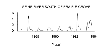
| PointID: | 3049 | Code: | 05OH009 | Latitude (decimal degrees): | 49.77 | Longitude (decimal degrees): | -96.95 | Drainage Area (km2): | Source: | Hydat | Hydrological Zone: | Nelson | Name: | SEINE RIVER SOUTH OF PRAIRIE GROVE |
|---|
| Download | |
|---|---|
| Site Descriptor Information | Site Time Series Data |
| Link to all available data | |
| ID | Year | Jan | Feb | Mar | Apr | May | Jun | Jul | Aug | Sep | Oct | Nov | Dec |
|---|---|---|---|---|---|---|---|---|---|---|---|---|---|
| 3049 | 1986 | 0.47 | 0.40 | 0.17 | 0.17 | 0.25 | |||||||
| 3049 | 1987 | 0.00 | 5.00 | 0.94 | 0.41 | 0.24 | 0.34 | 0.05 | 0.21 | ||||
| 3049 | 1988 | 0.00 | 1.00 | 0.49 | 0.12 | 0.08 | 5.0e-03 | 0.00 | 0.02 | ||||
| 3049 | 1989 | 0.00 | 1.00 | 0.97 | 0.93 | 0.54 | 0.13 | 0.05 | 0.12 | ||||
| 3049 | 1990 | 0.00 | 0.00 | 0.72 | 1.37 | 0.48 | 0.01 | 0.00 | 0.01 | ||||
| 3049 | 1991 | 0.00 | 0.00 | 1.27 | 0.81 | 1.69 | 0.08 | 0.13 | 0.70 | ||||
| 3049 | 1992 | 0.00 | 6.00 | 1.50 | 1.12 | 1.17 | 0.15 | 0.20 | 0.22 | ||||
| 3049 | 1993 | 0.00 | 3.00 | 1.24 | 0.93 | 3.11 | 3.56 | 2.90 | 0.97 |
 Return to R-Arctic Net Home Page