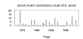
| PointID: | 3048 | Code: | 05OH008 | Latitude (decimal degrees): | 49.65 | Longitude (decimal degrees): | -96.65 | Drainage Area (km2): | 690.00 | Source: | Hydat | Hydrological Zone: | Nelson | Name: | SEINE RIVER DIVERSION NEAR STE. ANNE |
|---|
| Download | |
|---|---|
| Site Descriptor Information | Site Time Series Data |
| Link to all available data | |
| ID | Year | Jan | Feb | Mar | Apr | May | Jun | Jul | Aug | Sep | Oct | Nov | Dec |
|---|---|---|---|---|---|---|---|---|---|---|---|---|---|
| 3048 | 1973 | 1.00 | 0.00 | 0.45 | 0.49 | 0.07 | 0.09 | 0.21 | 1.15 | ||||
| 3048 | 1974 | 0.00 | 20.00 | 16.40 | 3.06 | 3.0e-03 | 3.0e-03 | 3.0e-03 | 3.0e-03 | ||||
| 3048 | 1975 | 0.00 | 1.00 | 2.23 | 1.45 | 2.23 | 0.00 | 0.00 | 0.00 | ||||
| 3048 | 1976 | 0.00 | 2.00 | 0.69 | 0.50 | 0.11 | 0.00 | 0.00 | 0.00 | ||||
| 3048 | 1977 | 0.00 | 0.00 | 1.0e-03 | 0.00 | 0.00 | 0.00 | 0.00 | 0.00 | ||||
| 3048 | 1978 | 0.00 | 8.00 | 1.61 | 0.06 | 0.01 | 1.0e-03 | 2.0e-03 | 0.00 | ||||
| 3048 | 1979 | 0.00 | 7.00 | 7.29 | 2.50 | 0.00 | 0.00 | 0.00 | 0.00 | ||||
| 3048 | 1980 | 0.00 | 1.00 | 0.00 | 0.00 | 0.00 | 0.00 | 0.00 | 0.00 | ||||
| 3048 | 1981 | 0.00 | 0.00 | 0.00 | 0.00 | 0.00 | 0.00 | 0.00 | 0.00 | ||||
| 3048 | 1982 | 0.00 | 4.00 | 0.11 | 2.25 | 1.71 | 0.16 | 0.00 | 0.16 | ||||
| 3048 | 1983 | 0.00 | 8.00 | 1.85 | 0.87 | 1.05 | 0.00 | 0.00 | 0.00 | ||||
| 3048 | 1984 | 0.00 | 0.00 | 0.02 | 5.32 | 0.15 | 0.00 | 0.00 | 0.00 | ||||
| 3048 | 1985 | 0.00 | 0.00 | 1.34 | 0.11 | 0.06 | 0.01 | 1.0e-03 | 0.19 | ||||
| 3048 | 1986 | 1.00 | 8.00 | 10.30 | 0.21 | 0.16 | 0.00 | 0.00 | 0.21 | ||||
| 3048 | 1987 | 0.00 | 5.00 | 0.02 | 0.00 | 0.00 | 0.00 | 0.00 | 0.00 | ||||
| 3048 | 1988 | 0.00 | 0.00 | 0.00 | 0.00 | 0.00 | 0.00 | 0.00 | 0.00 | ||||
| 3048 | 1989 | 0.00 | 0.00 | 0.15 | 0.07 | 9.0e-03 | 0.00 | 0.00 | 0.00 | ||||
| 3048 | 1990 | 0.00 | 0.00 | 0.82 | 5.81 | 0.06 | 0.00 | 0.00 | 0.00 | ||||
| 3048 | 1991 | 0.00 | 0.00 | 1.0e-03 | 0.01 | 1.15 | 0.00 | 0.00 | 0.10 | ||||
| 3048 | 1992 | 1.00 | 13.00 | 3.44 | 5.0e-03 | 0.06 | 0.00 | 0.00 | 0.00 | ||||
| 3048 | 1993 | 0.00 | 0.00 | 1.0e-03 | 1.0e-03 | 2.07 | 7.57 | 2.30 | 0.35 |
 Return to R-Arctic Net Home Page