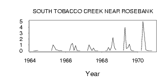
| PointID: | 3031 | Code: | 05OF019 | Latitude (decimal degrees): | 49.41 | Longitude (decimal degrees): | -98.16 | Drainage Area (km2): | 134.00 | Source: | Hydat | Hydrological Zone: | Nelson | Name: | SOUTH TOBACCO CREEK NEAR ROSEBANK |
|---|
| Download | |
|---|---|
| Site Descriptor Information | Site Time Series Data |
| Link to all available data | |
| ID | Year | Jan | Feb | Mar | Apr | May | Jun | Jul | Aug | Sep | Oct | Nov | Dec |
|---|---|---|---|---|---|---|---|---|---|---|---|---|---|
| 3031 | 1964 | 0.00 | 0.00 | 0.03 | 0.02 | ||||||||
| 3031 | 1965 | 0.00 | 1.00 | 0.61 | 0.14 | 0.10 | 0.00 | 0.02 | 0.00 | ||||
| 3031 | 1966 | 0.00 | 1.00 | 1.27 | 0.04 | 0.89 | 0.03 | 0.00 | 0.00 | ||||
| 3031 | 1967 | 0.00 | 1.00 | 0.45 | 0.03 | 0.47 | 0.00 | 0.00 | 0.00 | ||||
| 3031 | 1968 | 0.00 | 0.00 | 0.57 | 0.05 | 0.62 | 2.24 | 0.51 | 0.15 | ||||
| 3031 | 1969 | 0.00 | 4.00 | 0.38 | 0.52 | 1.12 | 0.10 | 0.01 | 0.01 | ||||
| 3031 | 1970 | 0.00 | 5.00 | 2.46 | 0.16 | 0.03 | 0.00 | 0.00 | 0.00 |
 Return to R-Arctic Net Home Page