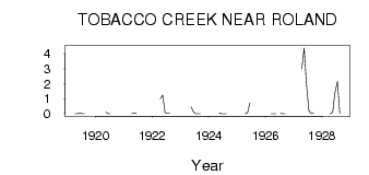
| PointID: | 3025 | Code: | 05OF012 | Latitude (decimal degrees): | 49.40 | Longitude (decimal degrees): | -97.93 | Drainage Area (km2): | 313.00 | Source: | Hydat | Hydrological Zone: | Nelson | Name: | TOBACCO CREEK NEAR ROLAND |
|---|
| Download | |
|---|---|
| Site Descriptor Information | Site Time Series Data |
| Link to all available data | |
| ID | Year | Jan | Feb | Mar | Apr | May | Jun | Jul | Aug | Sep | Oct | Nov | Dec |
|---|---|---|---|---|---|---|---|---|---|---|---|---|---|
| 3025 | 1919 | 0.00 | 7.0e-03 | 0.06 | 0.01 | 0.00 | |||||||
| 3025 | 1920 | 0.11 | 4.0e-03 | 0.00 | |||||||||
| 3025 | 1921 | 0.00 | 0.05 | 0.01 | |||||||||
| 3025 | 1922 | 1.00 | 1.25 | 0.09 | 0.03 | 0.02 | |||||||
| 3025 | 1923 | 0.47 | 0.15 | 9.0e-03 | 0.00 | 0.00 | |||||||
| 3025 | 1924 | 0.06 | 0.00 | 0.00 | 0.00 | ||||||||
| 3025 | 1925 | 0.00 | 0.07 | 0.73 | |||||||||
| 3025 | 1926 | 0.00 | 0.00 | 0.01 | 0.03 | 0.00 | 0.01 | ||||||
| 3025 | 1927 | 3.00 | 4.38 | 1.92 | 0.21 | 0.00 | 0.07 | ||||||
| 3025 | 1928 | 0.00 | 0.11 | 1.38 | 2.14 | 0.02 |
 Return to R-Arctic Net Home Page