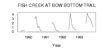
| PointID: | 302 | Code: | 05BK003 | Latitude (decimal degrees): | 50.90 | Longitude (decimal degrees): | -114.01 | Drainage Area (km2): | 437.00 | Source: | Hydat | Hydrological Zone: | Nelson | Name: | FISH CREEK AT BOW BOTTOM TRAIL |
|---|
| Download | |
|---|---|
| Site Descriptor Information | Site Time Series Data |
| Link to all available data | |
| ID | Year | Jan | Feb | Mar | Apr | May | Jun | Jul | Aug | Sep | Oct | Nov | Dec |
|---|---|---|---|---|---|---|---|---|---|---|---|---|---|
| 302 | 1989 | 0.14 | 0.08 | 0.27 | 0.14 | ||||||||
| 302 | 1990 | 2.98 | 3.49 | 0.89 | 1.26 | 0.21 | 0.30 | ||||||
| 302 | 1991 | 2.17 | 1.93 | 1.21 | 0.28 | 0.15 | 0.20 | ||||||
| 302 | 1992 | 0.33 | 4.22 | 1.79 | 0.83 | 0.56 | 0.54 | ||||||
| 302 | 1993 | 1.95 | 4.27 | 3.19 | 3.04 | 2.09 | 1.06 |
 Return to R-Arctic Net Home Page