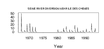
| PointID: | 3014 | Code: | 05OE011 | Latitude (decimal degrees): | 49.69 | Longitude (decimal degrees): | -96.98 | Drainage Area (km2): | 1410.00 | Source: | Hydat | Hydrological Zone: | Nelson | Name: | SEINE RIVER DIVERSION NEAR ILE DES CHENES |
|---|
| Download | |
|---|---|
| Site Descriptor Information | Site Time Series Data |
| Link to all available data | |
| ID | Year | Jan | Feb | Mar | Apr | May | Jun | Jul | Aug | Sep | Oct | Nov | Dec |
|---|---|---|---|---|---|---|---|---|---|---|---|---|---|
| 3014 | 1967 | 1.00 | 50.00 | 6.97 | 0.04 | 0.02 | 8.0e-03 | 0.01 | 0.04 | ||||
| 3014 | 1968 | 0.00 | 2.00 | 4.12 | 1.52 | 1.01 | 2.33 | 1.31 | 0.21 | ||||
| 3014 | 1969 | 0.00 | 21.00 | 5.13 | 0.88 | 0.55 | 0.19 | 0.03 | 0.09 | ||||
| 3014 | 1970 | 0.00 | 23.00 | 18.60 | 7.00 | 0.37 | 0.03 | 0.23 | 0.09 | ||||
| 3014 | 1971 | 0.00 | 14.00 | 2.67 | 0.49 | 0.16 | 0.04 | 0.11 | 0.73 | ||||
| 3014 | 1972 | 1.00 | 13.00 | 1.88 | 0.07 | 0.03 | 0.07 | 0.03 | 0.18 | ||||
| 3014 | 1980 | 0.00 | 6.00 | 0.08 | 0.04 | 0.02 | 0.01 | 0.26 | 0.42 | ||||
| 3014 | 1981 | 0.00 | 0.00 | 0.25 | 0.39 | 0.56 | 0.40 | 0.27 | 0.46 | ||||
| 3014 | 1982 | 0.00 | 10.00 | 0.44 | 3.69 | 3.01 | 0.55 | 0.18 | 0.62 | ||||
| 3014 | 1983 | 7.00 | 15.00 | 2.36 | 1.28 | 1.37 | 0.05 | 0.07 | 0.12 | ||||
| 3014 | 1984 | 0.00 | 0.00 | 0.28 | 6.03 | 0.38 | 0.06 | 0.07 | 0.24 | ||||
| 3014 | 1985 | 5.00 | 1.00 | 1.70 | 0.12 | 0.24 | 1.23 | 0.09 | 0.33 | ||||
| 3014 | 1986 | 8.00 | 13.00 | 18.00 | 0.36 | 0.42 | 0.14 | 0.12 | 0.46 | ||||
| 3014 | 1987 | 0.00 | 12.00 | 0.21 | 0.12 | 0.08 | 0.08 | 0.03 | 0.18 | ||||
| 3014 | 1988 | 0.00 | 2.00 | 0.03 | 0.01 | 0.04 | 4.0e-03 | 0.01 | 0.09 | ||||
| 3014 | 1989 | 0.00 | 4.00 | 0.33 | 0.20 | 0.21 | 0.04 | 0.02 | 0.11 | ||||
| 3014 | 1990 | 1.00 | 2.00 | 1.01 | 8.30 | 0.36 | 0.02 | 0.03 | 0.06 | ||||
| 3014 | 1991 | 0.00 | 0.00 | 0.28 | 0.18 | 1.40 | 0.05 | 0.12 | 0.22 | ||||
| 3014 | 1992 | 5.00 | 23.00 | 4.00 | 0.28 | 0.23 | 0.05 | 0.10 | 0.12 | ||||
| 3014 | 1993 | 2.00 | 3.00 | 0.18 | 0.07 | 3.11 | 9.56 | 2.69 | 0.74 |
 Return to R-Arctic Net Home Page