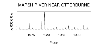
| PointID: | 3013 | Code: | 05OE010 | Latitude (decimal degrees): | 49.50 | Longitude (decimal degrees): | -97.15 | Drainage Area (km2): | 393.00 | Source: | Hydat | Hydrological Zone: | Nelson | Name: | MARSH RIVER NEAR OTTERBURNE |
|---|
| Download | |
|---|---|
| Site Descriptor Information | Site Time Series Data |
| Link to all available data | |
| ID | Year | Jan | Feb | Mar | Apr | May | Jun | Jul | Aug | Sep | Oct | Nov | Dec |
|---|---|---|---|---|---|---|---|---|---|---|---|---|---|
| 3013 | 1971 | 0.00 | 7.00 | 0.16 | 0.02 | 3.0e-03 | 0.00 | 0.00 | 0.00 | ||||
| 3013 | 1972 | 0.00 | 3.00 | 0.16 | 0.01 | 1.0e-03 | 1.0e-03 | 1.0e-03 | 1.0e-03 | ||||
| 3013 | 1973 | 0.00 | 0.00 | 0.02 | 3.0e-03 | 0.00 | 0.00 | 0.04 | 0.00 | ||||
| 3013 | 1974 | 0.00 | 25.00 | 18.90 | 0.93 | 0.01 | 0.00 | 0.00 | 0.00 | ||||
| 3013 | 1975 | 0.00 | 0.00 | 5.62 | 0.76 | 2.11 | 7.0e-03 | 0.00 | 0.00 | ||||
| 3013 | 1976 | 0.00 | 3.00 | 0.07 | 0.09 | 0.02 | 0.00 | 0.00 | 0.00 | ||||
| 3013 | 1977 | 0.00 | 0.00 | 0.12 | 0.12 | 6.0e-03 | 0.00 | 0.01 | 5.0e-03 | ||||
| 3013 | 1978 | 0.00 | 26.00 | 2.82 | 0.00 | 0.01 | 0.00 | 0.00 | 0.00 | ||||
| 3013 | 1979 | 0.00 | 27.00 | 55.50 | 0.56 | 1.0e-03 | 1.0e-03 | 0.00 | 1.0e-03 | ||||
| 3013 | 1980 | 0.00 | 2.00 | 0.07 | 0.01 | 1.0e-03 | 4.0e-03 | 2.0e-03 | 0.01 | ||||
| 3013 | 1981 | 0.00 | 0.00 | 0.40 | 0.53 | 0.14 | 0.14 | 0.09 | 0.04 | ||||
| 3013 | 1982 | 0.00 | 3.00 | 0.17 | 0.45 | 0.13 | 0.02 | 0.00 | 0.00 | ||||
| 3013 | 1983 | 1.00 | 7.00 | 0.22 | 0.00 | 0.00 | 0.00 | 0.00 | 0.00 | ||||
| 3013 | 1984 | 0.00 | 0.00 | 0.04 | 0.82 | 0.16 | 0.01 | 0.00 | 0.00 | ||||
| 3013 | 1985 | 2.00 | 0.00 | 3.0e-03 | 0.00 | 0.00 | 0.01 | 7.0e-03 | 1.0e-03 | ||||
| 3013 | 1986 | 1.00 | 5.00 | 2.24 | 0.03 | 0.00 | 0.00 | 0.00 | 0.00 | ||||
| 3013 | 1987 | 0.00 | 12.00 | 6.0e-03 | 0.00 | 0.00 | 0.00 | 0.00 | 0.00 | ||||
| 3013 | 1988 | 0.00 | 0.00 | 0.02 | 0.00 | 0.00 | 0.00 | 0.00 | 0.00 | ||||
| 3013 | 1989 | 0.00 | 6.00 | 0.73 | 8.0e-03 | 0.00 | 0.00 | 0.00 | 0.00 | ||||
| 3013 | 1990 | 0.00 | 2.00 | 0.03 | 0.94 | 0.05 | 0.00 | 0.00 | 0.00 | ||||
| 3013 | 1991 | 0.00 | 0.00 | 0.62 | 1.0e-03 | 1.38 | 0.05 | 0.00 | 0.00 | ||||
| 3013 | 1992 | 0.00 | 14.00 | 1.01 | 6.0e-03 | 7.0e-03 | 0.00 | 0.00 | 0.00 | ||||
| 3013 | 1993 | 0.00 | 3.00 | 0.01 | 3.0e-03 | 5.08 | 3.26 | 0.05 | 6.0e-03 |
 Return to R-Arctic Net Home Page