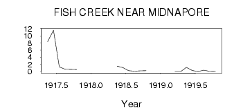
| PointID: | 301 | Code: | 05BK002 | Latitude (decimal degrees): | 50.92 | Longitude (decimal degrees): | -114.06 | Drainage Area (km2): | 428.00 | Source: | Hydat | Hydrological Zone: | Nelson | Name: | FISH CREEK NEAR MIDNAPORE |
|---|
| Download | |
|---|---|
| Site Descriptor Information | Site Time Series Data |
| Link to all available data | |
| ID | Year | Jan | Feb | Mar | Apr | May | Jun | Jul | Aug | Sep | Oct | Nov | Dec |
|---|---|---|---|---|---|---|---|---|---|---|---|---|---|
| 301 | 1917 | 8.38 | 11.60 | 1.30 | 0.68 | 0.61 | 0.56 | ||||||
| 301 | 1918 | 1.51 | 1.14 | 0.26 | 0.13 | 0.18 | 0.26 | ||||||
| 301 | 1919 | 0.00 | 0.00 | 1.16 | 0.27 | 6.0e-03 | 0.38 | 0.04 | 0.10 |
 Return to R-Arctic Net Home Page