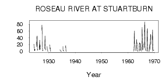
| PointID: | 2997 | Code: | 05OD014 | Latitude (decimal degrees): | 49.13 | Longitude (decimal degrees): | -96.76 | Drainage Area (km2): | 4500.00 | Source: | Hydat | Hydrological Zone: | Nelson | Name: | ROSEAU RIVER AT STUARTBURN |
|---|
| Download | |
|---|---|
| Site Descriptor Information | Site Time Series Data |
| Link to all available data | |
| ID | Year | Jan | Feb | Mar | Apr | May | Jun | Jul | Aug | Sep | Oct | Nov | Dec |
|---|---|---|---|---|---|---|---|---|---|---|---|---|---|
| 2997 | 1924 | 21.20 | 5.85 | 2.27 | 6.13 | 2.03 | 6.53 | ||||||
| 2997 | 1925 | 27.00 | 14.20 | 42.00 | 45.80 | 3.36 | 4.14 | 6.31 | |||||
| 2997 | 1926 | 15.00 | 5.27 | 17.30 | 33.60 | 4.59 | 7.54 | 19.00 | |||||
| 2997 | 1927 | 62.00 | 78.00 | 55.50 | 14.10 | 1.43 | 2.67 | 3.74 | 4.00 | ||||
| 2997 | 1928 | 9.00 | 8.27 | 20.10 | 45.70 | 17.60 | 6.03 | 3.77 | |||||
| 2997 | 1929 | 15.00 | 5.28 | 5.28 | 2.12 | 0.22 | 0.27 | ||||||
| 2997 | 1930 | 19.80 | 6.28 | 10.90 | 0.52 | 0.16 | |||||||
| 2997 | 1934 | 5.00 | 1.86 | 1.37 | 0.47 | 0.05 | 0.04 | 0.93 | |||||
| 2997 | 1935 | 15.00 | 8.44 | 2.50 | 3.29 | 1.29 | 1.29 | 0.72 | |||||
| 2997 | 1936 | 12.00 | 17.30 | 2.69 | 0.29 | 4.0e-03 | 0.52 | ||||||
| 2997 | 1962 | 0.00 | 13.00 | 42.70 | 60.50 | 27.30 | 24.80 | 10.40 | 1.86 | ||||
| 2997 | 1963 | 2.00 | 36.00 | 23.40 | 24.90 | 8.42 | 1.52 | 0.25 | 0.69 | ||||
| 2997 | 1964 | 0.00 | 18.00 | 25.90 | 22.20 | 24.30 | 2.50 | 2.84 | 23.10 | ||||
| 2997 | 1965 | 0.00 | 37.00 | 71.30 | 42.60 | 24.40 | 3.88 | 7.43 | 22.60 | ||||
| 2997 | 1966 | 10.00 | 75.00 | 87.90 | 46.60 | 16.70 | 5.31 | 4.62 | 1.97 | ||||
| 2997 | 1967 | 0.00 | 58.00 | 68.30 | 23.30 | 3.70 | 0.56 | 0.03 | 0.04 | ||||
| 2997 | 1968 | 0.00 | 20.00 | 5.36 | 32.80 | 50.80 | 48.70 | 47.40 | 20.60 | ||||
| 2997 | 1969 | 0.00 | 45.00 | 63.70 | 20.80 | 3.97 | 4.05 | 1.90 | 4.44 |
 Return to R-Arctic Net Home Page