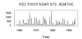
| PointID: | 2983 | Code: | 05OC012 | Latitude (decimal degrees): | 49.56 | Longitude (decimal degrees): | -97.18 | Drainage Area (km2): | 115000.00 | Source: | Hydat | Hydrological Zone: | Nelson | Name: | RED RIVER NEAR STE. AGATHE |
|---|
| Download | |
|---|---|
| Site Descriptor Information | Site Time Series Data |
| Link to all available data | |
| ID | Year | Jan | Feb | Mar | Apr | May | Jun | Jul | Aug | Sep | Oct | Nov | Dec |
|---|---|---|---|---|---|---|---|---|---|---|---|---|---|
| 2983 | 1958 | 49.60 | 44.40 | 136.00 | 35.30 | 17.20 | 18.40 | ||||||
| 2983 | 1959 | 16.00 | 218.00 | 101.00 | 121.00 | 69.40 | 27.80 | 18.10 | 40.40 | ||||
| 2983 | 1960 | 13.00 | 625.00 | 209.00 | 119.00 | 80.20 | 22.10 | 21.90 | 11.00 | 19.00 | 10.00 | ||
| 2983 | 1961 | 9.00 | 8.00 | 52.00 | 96.00 | 84.90 | 38.80 | 14.40 | 9.20 | 8.54 | 21.00 | 14.00 | 8.00 |
| 2983 | 1962 | 5.00 | 5.00 | 8.00 | 532.00 | 442.00 | 743.00 | 504.00 | 255.00 | 117.00 | 71.50 | 61.00 | 48.00 |
| 2983 | 1963 | 33.00 | 30.00 | 44.00 | 281.00 | 127.00 | 273.00 | 104.00 | 43.80 | 35.90 | 40.30 | 28.00 | 20.00 |
| 2983 | 1964 | 21.00 | 22.00 | 19.00 | 312.00 | 197.00 | 277.00 | 147.00 | 46.30 | 31.70 | 69.20 | 44.00 | 28.00 |
| 2983 | 1965 | 25.00 | 25.00 | 26.00 | 761.00 | 666.00 | 333.00 | 187.00 | 74.50 | 66.60 | 143.00 | 105.00 | 101.00 |
| 2983 | 1966 | 76.00 | 53.00 | 147.00 | 1530.00 | 747.00 | 254.00 | 222.00 | 114.00 | 98.80 | 55.60 | 54.00 | 50.00 |
| 2983 | 1967 | 41.00 | 36.00 | 50.00 | 935.00 | 674.00 | 219.00 | 114.00 | 43.10 | 27.10 | 27.50 | 17.00 | 18.00 |
| 2983 | 1968 | 15.00 | 12.00 | 44.00 | 188.00 | 89.60 | 195.00 | 249.00 | 174.00 | 151.00 | 82.30 | 60.00 | 51.00 |
| 2983 | 1969 | 40.00 | 35.00 | 53.00 | 815.00 | 961.00 | 225.00 | 141.00 | 68.70 | 49.90 | 62.50 | 58.00 | 44.00 |
| 2983 | 1970 | 40.00 | 36.00 | 40.00 | 645.00 | 954.00 | 586.00 | 225.00 | 47.60 | 41.50 | 37.60 | 44.00 | 31.00 |
| 2983 | 1971 | 29.00 | 26.00 | 65.00 | 604.00 | 186.00 | 103.00 | 84.90 | 44.60 | 44.40 | 112.00 | 155.00 | 62.00 |
| 2983 | 1972 | 44.00 | 46.00 | 181.00 | 750.00 | 387.00 | 190.00 | 74.50 | 73.80 | 58.00 | 55.80 | 42.00 | 30.00 |
| 2983 | 1973 | 29.00 | 31.00 | 192.00 | 84.00 | 54.30 | 41.40 | 20.10 | 20.60 | 69.60 | 139.00 | 80.00 | 61.00 |
| 2983 | 1974 | 49.00 | 48.00 | 56.00 | 657.00 | 1120.00 | 402.00 | 113.00 | 98.60 | 73.90 | 61.40 | 61.00 | 38.00 |
| 2983 | 1975 | 35.00 | 39.00 | 46.00 | 367.00 | 894.00 | 229.00 | 837.00 | 172.00 | 72.60 | 65.00 | 60.00 | 50.00 |
| 2983 | 1976 | 45.00 | 48.00 | 68.00 | 625.00 | 153.00 | 78.50 | 47.90 | 30.60 | 21.40 | 10.90 | 8.00 | 4.00 |
| 2983 | 1977 | 4.00 | 5.00 | 10.00 | 66.00 | 40.00 | 27.20 | 17.00 | 8.23 | 12.80 | 42.00 | 25.00 | 40.00 |
| 2983 | 1978 | 36.00 | 31.00 | 42.00 | 1040.00 | 430.00 | 127.00 | 105.00 | 58.90 | 41.10 | 31.60 | 19.00 | 21.00 |
| 2983 | 1979 | 17.00 | 17.00 | 22.00 | 680.00 | 1760.00 | 309.00 | 199.00 | 101.00 | 62.70 | 44.00 | 50.00 | 39.00 |
| 2983 | 1980 | 38.00 | 38.00 | 43.00 | 342.00 | 70.80 | 51.30 | 24.40 | 17.40 | 25.80 | 14.10 | 10.00 | 11.00 |
| 2983 | 1981 | 7.00 | 8.00 | 42.00 | 54.00 | 39.40 | 55.90 | 87.30 | 40.70 | 59.50 | 77.00 | 61.00 | 35.00 |
| 2983 | 1982 | 31.00 | 28.00 | 42.00 | 688.00 | 304.00 | 147.00 | 129.00 | 78.90 | 40.50 | 139.00 | 75.00 | 60.00 |
| 2983 | 1983 | 44.00 | 40.00 | 328.00 | 527.00 | 137.00 | 150.00 | 208.00 | 72.10 | 87.70 | 62.70 | 61.00 | 47.00 |
| 2983 | 1984 | 39.00 | 37.00 | 77.00 | 586.00 | 132.00 | 334.00 | 113.00 | 44.90 | 32.00 | 53.90 | 61.00 | 43.00 |
| 2983 | 1985 | 33.00 | 29.00 | 200.00 | 283.00 | 290.00 | 274.00 | 239.00 | 236.00 | 204.00 | 145.00 | 87.00 | 56.00 |
| 2983 | 1986 | 51.00 | 45.00 | 180.00 | 884.00 | 729.00 | 259.00 | 155.00 | 78.40 | 73.20 | 104.00 | 64.00 | 56.00 |
| 2983 | 1987 | 54.00 | 46.00 | 180.00 | 777.00 | 131.00 | 123.00 | 90.80 | 85.30 | 29.60 | 20.50 | 17.00 | 20.00 |
| 2983 | 1988 | 15.00 | 17.00 | 68.00 | 203.00 | 40.30 | 35.50 | 15.60 | 11.20 | 9.54 | 10.70 | 7.00 | 7.00 |
| 2983 | 1989 | 7.00 | 8.00 | 10.00 | 579.00 | 263.00 | 84.60 | 47.20 | 13.80 | 29.20 | 13.50 | 8.00 | 6.00 |
| 2983 | 1990 | 3.00 | 6.00 | 32.00 | 187.00 | 54.10 | 73.00 | 45.10 | 13.80 | 11.30 | 8.53 | 7.00 | 5.00 |
| 2983 | 1991 | 3.00 | 6.00 | 15.00 | 69.00 | 87.90 | 83.30 | 171.00 | 43.00 | 55.10 | 34.40 | 33.00 | 18.00 |
| 2983 | 1992 | 15.00 | 15.00 | 205.00 | 504.00 | 201.00 | 94.70 | 99.30 | 38.50 | 87.40 | 41.10 | 22.00 | 25.00 |
| 2983 | 1993 | 26.00 | 29.00 | 45.00 | 497.00 | 136.00 | 150.00 | 352.00 | 871.00 | 333.00 | 132.00 | 90.00 | 64.00 |
 Return to R-Arctic Net Home Page