| PointID: | 2950 | Code: | 05NG024 | Latitude (decimal degrees): | 49.84 | Longitude (decimal degrees): | -101.39 | Drainage Area (km2): | 1340.00 | Source: | Hydat | Hydrological Zone: | Nelson | Name: | PIPESTONE CREEK NEAR THE SASKATCHEWAN BOUNDARY |
|---|
| Download | |
|---|---|
| Site Descriptor Information | Site Time Series Data |
| Link to all available data | |
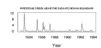
| ID | Year | Jan | Feb | Mar | Apr | May | Jun | Jul | Aug | Sep | Oct | Nov | Dec |
|---|---|---|---|---|---|---|---|---|---|---|---|---|---|
| 2950 | 1982 | 2.0e-03 | 0.40 | 0.00 | 0.00 | ||||||||
| 2950 | 1983 | 0.00 | 0.00 | 0.00 | 12.00 | 3.04 | 0.55 | 0.02 | 0.12 | 0.43 | 1.0e-03 | 0.00 | 0.00 |
| 2950 | 1984 | 0.00 | 0.00 | 0.00 | 0.00 | 0.02 | 1.0e-03 | 0.00 | 0.06 | 0.21 | 0.07 | 0.00 | 0.00 |
| 2950 | 1985 | 0.00 | 0.00 | 0.00 | 8.00 | 1.16 | 0.09 | 8.0e-03 | 0.09 | 0.18 | 0.26 | 0.00 | 0.00 |
| 2950 | 1986 | 0.00 | 0.00 | 6.00 | 1.00 | 3.19 | 0.69 | 0.21 | 0.03 | 0.04 | 0.47 | 0.00 | 0.00 |
| 2950 | 1987 | 0.00 | 0.00 | 1.00 | 5.00 | 0.05 | 0.01 | 0.04 | 0.01 | 0.19 | 0.29 | 0.00 | 0.00 |
| 2950 | 1988 | 0.00 | 0.00 | 0.00 | 0.00 | 0.03 | 1.0e-03 | 0.00 | 0.00 | 0.01 | 0.13 | 0.00 | 0.00 |
| 2950 | 1989 | 0.00 | 0.00 | 0.00 | 0.00 | 0.01 | 0.00 | 0.00 | 0.00 | 0.15 | 0.02 | 0.00 | 0.00 |
| 2950 | 1990 | 0.00 | 0.00 | 0.00 | 1.00 | 0.15 | 0.30 | 0.09 | 1.0e-03 | 0.00 | 0.30 | 0.00 | 0.00 |
| 2950 | 1991 | 0.00 | 0.00 | 0.00 | 0.00 | 0.68 | 0.12 | 0.60 | 0.48 | 0.01 | 1.0e-03 | 0.00 | 0.00 |
| 2950 | 1992 | 0.00 | 0.00 | 5.00 | 3.00 | 1.36 | 0.21 | 0.03 | 0.00 | 0.00 | 0.13 | 0.00 | 0.00 |
| 2950 | 1993 | 0.00 | 0.00 | 0.00 | 0.00 | 0.03 | 2.0e-03 | 0.51 | 0.18 | 0.43 | 0.08 | 0.00 | 0.00 |
 Return to R-Arctic Net Home Page