| PointID: | 2943 | Code: | 05NG011 | Latitude (decimal degrees): | 49.18 | Longitude (decimal degrees): | -100.43 | Drainage Area (km2): | 93.80 | Source: | Hydat | Hydrological Zone: | Nelson | Name: | TURTLEHEAD CREEK NEAR DELORAINE |
|---|
| Download | |
|---|---|
| Site Descriptor Information | Site Time Series Data |
| Link to all available data | |
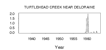
| ID | Year | Jan | Feb | Mar | Apr | May | Jun | Jul | Aug | Sep | Oct | Nov | Dec |
|---|---|---|---|---|---|---|---|---|---|---|---|---|---|
| 2943 | 1936 | 0.02 | |||||||||||
| 2943 | 1959 | 0.00 | 0.00 | 8.0e-03 | 2.0e-03 | 0.00 | 0.09 | 0.01 | 1.54 | ||||
| 2943 | 1960 | 0.00 | 2.00 | 0.92 | 0.33 | 0.00 | 0.00 | 0.00 | 0.00 | ||||
| 2943 | 1961 | 0.00 | 0.00 | 0.02 | 0.00 | 0.00 | 0.00 | 0.00 | 0.00 | ||||
| 2943 | 1962 | 0.00 | 0.00 | 0.02 | 0.09 | 3.0e-03 | 0.00 | 0.00 | 0.00 | ||||
| 2943 | 1963 | 0.00 | 0.00 | 2.0e-03 | 0.16 | 0.00 | 0.00 | 0.00 | 0.00 |
 Return to R-Arctic Net Home Page