SOURIS RIVER AT WAWANESA
Nelson
| PointID: | 2938 |
Code: | 05NG001 |
Latitude (decimal degrees): | 49.60 |
Longitude (decimal degrees): | -99.68 |
Drainage Area (km2): | 61100.00 |
Source: | Hydat |
Hydrological Zone: | Nelson |
Name: | SOURIS RIVER AT WAWANESA |
Field Definitions
Site Time Series Plot:
Site Data File:
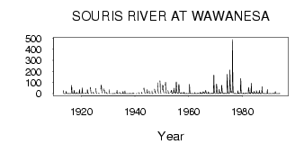
(Units: m3/s)
| ID | Year | Jan | Feb | Mar | Apr | May | Jun | Jul | Aug | Sep | Oct | Nov | Dec |
|---|
| 2938 | 1912 | | | | | | | | | | 2.27 | | |
| 2938 | 1913 | 0.00 | | | 27.00 | 28.00 | 4.71 | 1.42 | 1.18 | 1.23 | 1.05 | 0.00 | 0.00 |
| 2938 | 1914 | 0.00 | 0.00 | 0.00 | 14.00 | 19.30 | 6.70 | 4.62 | 2.76 | 1.56 | 0.80 | 0.00 | 0.00 |
| 2938 | 1915 | 0.00 | 0.00 | 0.00 | 3.00 | 1.91 | 1.41 | 1.13 | 0.12 | 0.84 | 0.94 | 0.00 | 0.00 |
| 2938 | 1916 | 0.00 | 0.00 | 0.00 | 56.00 | 74.50 | 46.60 | 13.70 | 6.16 | 2.38 | 2.24 | 1.00 | 0.00 |
| 2938 | 1917 | 0.00 | 0.00 | 0.00 | 23.00 | 29.80 | 14.60 | 3.78 | 1.08 | 0.39 | 0.36 | 0.00 | 0.00 |
| 2938 | 1918 | 0.00 | 0.00 | 2.00 | 13.00 | 5.90 | 3.01 | 0.76 | 0.58 | 0.35 | 1.04 | 0.00 | 0.00 |
| 2938 | 1919 | 0.00 | 0.00 | 0.00 | 37.00 | 33.20 | 5.34 | 1.80 | 0.52 | 0.29 | 0.31 | 0.00 | 0.00 |
| 2938 | 1920 | 0.00 | 0.00 | 0.00 | 19.00 | 51.60 | 28.00 | 5.27 | 2.02 | 1.29 | 1.14 | 0.00 | |
| 2938 | 1921 | | | | 7.00 | 5.54 | 3.50 | 2.88 | 5.36 | 2.12 | 1.38 | 0.00 | |
| 2938 | 1922 | | | 0.00 | 36.00 | 30.70 | 13.10 | 3.83 | 2.21 | 1.14 | 0.97 | 1.00 | |
| 2938 | 1923 | | | | 46.00 | 57.40 | 40.20 | 16.70 | 13.00 | 3.89 | 2.52 | 2.00 | |
| 2938 | 1924 | | | | | 14.00 | 5.81 | 7.95 | 2.08 | 0.93 | 1.37 | | |
| 2938 | 1925 | | | | 48.00 | 39.80 | 28.70 | 8.30 | 2.32 | 1.28 | 1.42 | | |
| 2938 | 1926 | | | | 3.00 | 3.11 | 2.22 | 2.82 | 1.41 | 1.21 | 1.26 | | |
| 2938 | 1927 | | | | 42.00 | 57.50 | 79.40 | 52.80 | 17.10 | 10.40 | 8.22 | 7.00 | |
| 2938 | 1928 | | | | 43.00 | 42.10 | 24.40 | 32.20 | 28.30 | 13.80 | 5.85 | 3.00 | |
| 2938 | 1929 | | | | 12.00 | 6.73 | 8.35 | 2.92 | 0.56 | 1.02 | 0.66 | 0.00 | |
| 2938 | 1930 | | | | 35.00 | 16.80 | 5.54 | 2.28 | 0.40 | 0.06 | 0.21 | | |
| 2938 | 1931 | | | | 1.00 | 0.33 | 0.14 | 0.08 | 2.0e-03 | 1.0e-03 | 1.0e-03 | 0.00 | 0.00 |
| 2938 | 1932 | 0.00 | 0.00 | 0.00 | 3.00 | 2.56 | 1.17 | 0.69 | 0.09 | 9.0e-03 | 0.10 | | |
| 2938 | 1933 | | | 2.00 | 29.00 | 10.40 | 2.57 | 4.26 | 1.48 | 0.77 | 0.11 | | |
| 2938 | 1934 | | | | 14.00 | 2.51 | 0.49 | 0.04 | 0.00 | 0.00 | 0.00 | 0.00 | 0.00 |
| 2938 | 1935 | 0.00 | 0.00 | | 4.00 | 2.66 | 2.06 | 20.60 | 4.76 | 0.93 | 0.23 | 0.00 | 0.00 |
| 2938 | 1936 | 0.00 | 0.00 | 0.00 | 24.00 | 2.55 | 0.71 | 0.04 | 0.00 | 0.00 | 0.00 | 0.00 | 0.00 |
| 2938 | 1937 | 0.00 | 0.00 | 0.00 | 0.00 | 0.30 | 0.42 | 0.05 | 0.12 | 1.0e-03 | 0.00 | 0.00 | 0.00 |
| 2938 | 1938 | 0.00 | 0.00 | 5.00 | 1.00 | 0.34 | 0.10 | 0.02 | 2.0e-03 | 0.00 | 0.00 | 0.00 | 0.00 |
| 2938 | 1939 | 0.00 | 0.00 | 3.00 | 8.00 | 0.29 | 0.21 | 0.02 | 0.00 | 0.00 | | | |
| 2938 | 1940 | | | | | 0.37 | 0.05 | 0.01 | 0.03 | 0.02 | | | |
| 2938 | 1941 | | | | 11.00 | 0.98 | 0.35 | 0.09 | 0.04 | 0.41 | 0.67 | | |
| 2938 | 1942 | | | | | 14.10 | 3.47 | 0.91 | 0.58 | 0.89 | | | |
| 2938 | 1943 | | | | 40.00 | 52.00 | 43.30 | 22.30 | 8.27 | 1.59 | 1.91 | | |
| 2938 | 1944 | | | | 5.00 | 9.03 | 9.31 | 35.60 | 8.52 | 8.94 | 4.79 | | |
| 2938 | 1945 | | | | 24.00 | 9.83 | 1.95 | 2.11 | 2.51 | 0.56 | 0.50 | | |
| 2938 | 1946 | | | | 24.00 | 2.49 | 0.91 | 0.76 | 0.26 | 1.01 | 1.62 | | |
| 2938 | 1947 | | | | 41.00 | 29.20 | 12.20 | 22.40 | 10.60 | 5.01 | 1.52 | | |
| 2938 | 1948 | | | | | 97.00 | 59.70 | 27.10 | 17.20 | 4.74 | 3.25 | | |
| 2938 | 1949 | | | | 116.00 | 94.00 | 30.40 | 8.23 | 4.03 | 2.35 | 1.83 | | |
| 2938 | 1950 | | | | 35.00 | 77.30 | 71.20 | 26.40 | 19.60 | 10.00 | 6.64 | | |
| 2938 | 1951 | | | | 73.00 | 104.00 | 60.70 | 17.80 | 3.21 | 4.80 | 4.24 | | |
| 2938 | 1952 | | | | 28.00 | 22.30 | 4.22 | 2.57 | 1.93 | 1.10 | 0.14 | | |
| 2938 | 1953 | | | | 10.00 | 16.00 | 23.70 | 30.40 | 30.40 | 6.35 | 3.11 | 6.00 | 1.00 |
| 2938 | 1954 | 3.00 | 3.00 | 4.00 | 10.00 | 9.90 | 28.80 | 48.80 | 22.30 | 8.23 | 16.80 | 11.00 | 6.00 |
| 2938 | 1955 | 5.00 | 4.00 | 3.00 | 97.00 | 105.00 | 78.60 | 44.30 | 16.20 | 9.27 | 9.13 | 4.00 | 1.00 |
| 2938 | 1956 | 0.00 | 0.00 | 0.00 | 74.00 | 83.90 | 66.80 | 21.70 | 10.10 | 7.45 | 6.47 | 7.00 | 2.00 |
| 2938 | 1957 | 1.00 | 0.00 | 5.00 | 9.00 | 10.40 | 9.10 | 5.70 | 5.20 | 3.94 | 2.66 | 3.00 | 2.00 |
| 2938 | 1958 | 0.00 | 0.00 | 4.00 | 15.00 | 4.58 | 3.20 | 1.44 | 0.50 | 0.48 | 0.65 | 0.00 | 0.00 |
| 2938 | 1959 | 0.00 | 0.00 | 2.00 | 3.00 | 0.67 | 0.60 | 0.55 | 0.17 | 0.52 | 1.63 | 3.00 | 1.00 |
| 2938 | 1960 | 0.00 | 0.00 | 0.00 | 85.00 | 41.70 | 17.20 | 2.35 | 0.80 | 0.95 | 1.10 | 0.00 | 0.00 |
| 2938 | 1961 | 0.00 | 0.00 | 0.00 | 3.00 | 1.13 | 0.33 | 0.34 | 0.01 | 0.04 | 0.21 | 0.00 | 0.00 |
| 2938 | 1962 | 0.00 | 0.00 | 0.00 | 10.00 | 1.37 | 1.55 | 0.56 | 0.72 | 0.82 | 1.27 | 0.00 | 0.00 |
| 2938 | 1963 | 0.00 | 0.00 | 0.00 | 3.00 | 1.26 | 5.93 | 3.56 | 0.57 | 0.66 | 0.61 | 0.00 | 0.00 |
| 2938 | 1964 | 0.00 | 0.00 | 0.00 | 13.00 | 13.50 | 2.04 | 4.67 | 0.94 | 2.14 | 3.62 | 0.00 | 0.00 |
| 2938 | 1965 | 0.00 | 0.00 | 0.00 | 17.00 | 12.90 | 17.00 | 14.60 | 6.09 | 8.37 | 7.57 | 2.00 | 1.00 |
| 2938 | 1966 | 1.00 | 1.00 | 20.00 | 23.00 | 30.00 | 13.00 | 4.73 | 2.02 | 0.75 | 0.78 | 0.00 | 0.00 |
| 2938 | 1967 | 0.00 | 0.00 | 0.00 | 15.00 | 16.90 | 5.31 | 0.68 | 0.22 | 0.08 | 0.66 | 0.00 | 0.00 |
| 2938 | 1968 | 0.00 | 0.00 | 3.00 | 1.00 | 0.69 | 0.49 | 0.74 | 1.36 | 5.97 | 5.66 | 1.00 | 0.00 |
| 2938 | 1969 | 0.00 | 0.00 | 0.00 | 159.00 | 168.00 | 79.90 | 24.60 | 18.70 | 4.03 | 2.14 | 1.00 | 1.00 |
| 2938 | 1970 | 1.00 | 1.00 | 1.00 | 32.00 | 85.90 | 84.70 | 50.90 | 15.80 | 3.02 | 2.65 | 2.00 | 0.00 |
| 2938 | 1971 | 0.00 | 0.00 | 1.00 | 23.00 | 39.50 | 20.00 | 13.20 | 11.10 | 2.22 | 3.27 | 6.00 | 3.00 |
| 2938 | 1972 | 2.00 | 2.00 | 19.00 | 74.00 | 75.80 | 25.60 | 20.30 | 7.24 | 4.11 | 4.16 | 6.00 | 0.00 |
| 2938 | 1973 | 0.00 | 0.00 | 3.00 | 1.00 | 5.25 | 3.80 | 3.54 | 2.06 | 2.14 | 4.39 | 1.00 | 0.00 |
| 2938 | 1974 | 0.00 | 0.00 | 1.00 | 121.00 | 174.00 | 119.00 | 38.80 | 5.77 | 3.27 | 2.43 | 3.00 | 1.00 |
| 2938 | 1975 | 1.00 | 0.00 | 1.00 | 48.00 | 212.00 | 175.00 | 86.50 | 22.40 | 10.40 | 26.80 | 24.00 | 12.00 |
| 2938 | 1976 | 9.00 | 7.00 | 7.00 | 488.00 | 286.00 | 107.00 | 38.30 | 20.10 | 11.10 | 3.71 | 2.00 | 1.00 |
| 2938 | 1977 | 1.00 | 1.00 | 1.00 | 2.00 | 1.96 | 1.06 | 1.13 | 0.49 | 1.04 | 0.82 | 0.00 | 0.00 |
| 2938 | 1978 | 0.00 | 0.00 | 0.00 | 25.00 | 13.00 | 2.65 | 4.44 | 6.13 | 4.23 | 0.52 | 0.00 | 0.00 |
| 2938 | 1979 | 0.00 | 0.00 | 1.00 | 28.00 | 137.00 | 118.00 | 37.10 | 6.23 | 1.62 | 1.03 | 0.00 | 0.00 |
| 2938 | 1980 | 0.00 | 0.00 | 0.00 | 6.00 | 4.97 | 1.18 | 0.77 | 1.29 | 1.34 | 3.36 | 3.00 | 1.00 |
| 2938 | 1981 | 1.00 | 3.00 | 7.00 | 6.00 | 4.52 | 4.11 | 2.22 | 1.98 | 1.84 | 1.56 | 1.00 | 0.00 |
| 2938 | 1982 | 0.00 | 0.00 | 1.00 | 40.00 | 57.70 | 26.60 | 3.04 | 3.41 | 4.39 | 6.38 | 8.00 | 1.00 |
| 2938 | 1983 | 1.00 | 2.00 | 13.00 | 95.00 | 67.10 | 11.70 | 6.07 | 4.92 | 11.70 | 6.44 | 6.00 | 1.00 |
| 2938 | 1984 | 0.00 | 1.00 | 4.00 | 7.00 | 20.50 | 17.60 | 3.53 | 2.14 | 1.75 | 2.51 | 2.00 | 1.00 |
| 2938 | 1985 | 0.00 | 0.00 | 25.00 | 20.00 | 15.80 | 10.80 | 1.73 | 2.65 | 4.61 | 5.05 | 2.00 | 1.00 |
| 2938 | 1986 | 1.00 | 1.00 | 13.00 | 18.00 | 30.20 | 8.22 | 2.63 | 2.50 | 0.93 | 5.39 | 2.00 | 1.00 |
| 2938 | 1987 | 1.00 | 1.00 | 10.00 | 63.00 | 24.30 | 5.49 | 3.91 | 6.58 | 4.68 | 2.29 | 2.00 | 1.00 |
| 2938 | 1988 | 0.00 | 0.00 | 1.00 | 2.00 | 0.54 | 0.12 | 0.53 | 0.02 | 0.20 | 0.57 | 0.00 | 0.00 |
| 2938 | 1989 | 0.00 | 0.00 | 0.00 | 38.00 | 2.73 | 0.51 | 0.33 | 0.31 | 0.29 | 0.55 | 0.00 | 0.00 |
| 2938 | 1990 | 0.00 | 0.00 | 0.00 | 3.00 | 0.50 | 0.56 | 0.74 | 0.21 | 0.22 | 0.39 | 0.00 | 0.00 |
| 2938 | 1991 | 0.00 | 0.00 | 0.00 | 0.00 | 0.52 | 3.39 | 5.21 | 1.29 | 0.47 | 0.90 | 0.00 | 0.00 |
| 2938 | 1992 | 0.00 | 0.00 | 15.00 | 18.00 | 4.01 | 0.90 | 0.75 | 0.22 | 0.52 | 0.68 | 0.00 | 0.00 |
| 2938 | 1993 | 0.00 | 0.00 | 1.00 | 1.00 | 0.27 | 0.16 | 0.61 | 0.71 | 3.13 | 1.37 | 0.00 | 0.00 |
All data provided by Environment Canada is copyright and its use is
restricted to non-commercial education and research purposes. Resale of
this data is prohibited. Any user of this data is required to give full
credit to Environment Canada as the source of the Canadian data. This
includes any research leading to a publication.
 Return to R-Arctic Net Home Page