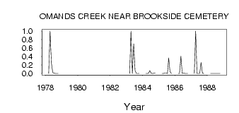
| PointID: | 2923 | Code: | 05MJ008 | Latitude (decimal degrees): | 49.91 | Longitude (decimal degrees): | -97.21 | Drainage Area (km2): | 65.80 | Source: | Hydat | Hydrological Zone: | Nelson | Name: | OMANDS CREEK NEAR BROOKSIDE CEMETERY |
|---|
| Download | |
|---|---|
| Site Descriptor Information | Site Time Series Data |
| Link to all available data | |
| ID | Year | Jan | Feb | Mar | Apr | May | Jun | Jul | Aug | Sep | Oct | Nov | Dec |
|---|---|---|---|---|---|---|---|---|---|---|---|---|---|
| 2923 | 1978 | 0.00 | 1.00 | 0.25 | 0.02 | 0.01 | 0.00 | 0.00 | 0.00 | ||||
| 2923 | 1983 | 0.00 | 1.00 | 0.00 | 0.70 | 0.07 | 2.0e-03 | 0.00 | 0.00 | ||||
| 2923 | 1984 | 0.00 | 0.00 | 5.0e-03 | 0.07 | 5.0e-03 | 0.00 | 4.0e-03 | 0.01 | ||||
| 2923 | 1985 | 0.00 | 0.00 | 0.01 | 8.0e-03 | 0.00 | 0.37 | 0.04 | 2.0e-03 | ||||
| 2923 | 1986 | 0.00 | 0.00 | 0.41 | 1.0e-03 | 0.01 | 0.00 | 0.00 | 0.00 | ||||
| 2923 | 1987 | 0.00 | 1.00 | 0.00 | 0.00 | 0.00 | 0.26 | 4.0e-03 | 2.0e-03 | ||||
| 2923 | 1988 | 0.00 | 0.00 | 0.00 | 0.00 | 0.00 | 0.00 | 0.00 | 0.00 |
 Return to R-Arctic Net Home Page