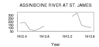
| PointID: | 2918 | Code: | 05MJ002 | Latitude (decimal degrees): | 49.87 | Longitude (decimal degrees): | -97.19 | Drainage Area (km2): | 154000.00 | Source: | Hydat | Hydrological Zone: | Nelson | Name: | ASSINIBOINE RIVER AT ST. JAMES |
|---|
| Download | |
|---|---|
| Site Descriptor Information | Site Time Series Data |
| Link to all available data | |
| ID | Year | Jan | Feb | Mar | Apr | May | Jun | Jul | Aug | Sep | Oct | Nov | Dec |
|---|---|---|---|---|---|---|---|---|---|---|---|---|---|
| 2918 | 1912 | 179.00 | 188.00 | 80.20 | 60.30 | 87.90 | 130.00 | ||||||
| 2918 | 1913 | 283.00 | 337.00 | 141.00 | 118.00 | 113.00 |
| Other Close Sites | ||||||
|---|---|---|---|---|---|---|
| PointID | Latitude | Longitude | Drainage Area | Source | Name | |
| 2917 | 49.86 | -97.40 | 153000.00 | Hydat | ASSINIBOINE RIVER AT HEADINGLEY | |
 Return to R-Arctic Net Home Page