| PointID: | 291 | Code: | 05BH904 | Latitude (decimal degrees): | 51.20 | Longitude (decimal degrees): | -114.16 | Drainage Area (km2): | 247.00 | Source: | Hydat | Hydrological Zone: | Nelson | Name: | BEDDINGTON CREEK NEAR CALGARY |
|---|
| Download | |
|---|---|
| Site Descriptor Information | Site Time Series Data |
| Link to all available data | |
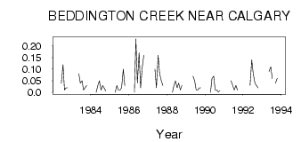
| ID | Year | Jan | Feb | Mar | Apr | May | Jun | Jul | Aug | Sep | Oct | Nov | Dec |
|---|---|---|---|---|---|---|---|---|---|---|---|---|---|
| 291 | 1982 | 0.04 | 0.12 | 0.01 | 0.02 | 0.02 | |||||||
| 291 | 1983 | 0.08 | 0.04 | 0.05 | 0.01 | 0.02 | 0.03 | ||||||
| 291 | 1984 | 0.00 | 0.03 | 0.05 | 0.01 | 0.03 | 0.02 | 6.0e-03 | |||||
| 291 | 1985 | 0.00 | 0.03 | 0.01 | 0.01 | 0.02 | 0.10 | 0.03 | |||||
| 291 | 1986 | 0.00 | 0.23 | 0.04 | 0.17 | 0.02 | 0.11 | 0.16 | |||||
| 291 | 1987 | 0.10 | 0.02 | 0.16 | 0.08 | 0.05 | 0.03 | ||||||
| 291 | 1988 | 0.00 | 0.03 | 0.05 | 0.02 | 0.04 | 0.01 | 0.03 | |||||
| 291 | 1989 | 0.07 | 0.05 | 0.01 | 0.01 | 0.02 | 0.02 | ||||||
| 291 | 1990 | 0.00 | 0.06 | 0.07 | 0.01 | 0.01 | 1.0e-03 | 8.0e-03 | |||||
| 291 | 1991 | 0.05 | 0.03 | 0.01 | 0.03 | 0.01 | |||||||
| 291 | 1992 | 0.03 | 0.14 | 0.08 | 0.04 | 0.03 | 0.02 | ||||||
| 291 | 1993 | 0.09 | 0.11 | 0.06 | 0.04 | 0.06 |
 Return to R-Arctic Net Home Page