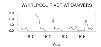
| PointID: | 2893 | Code: | 05MF009 | Latitude (decimal degrees): | 50.56 | Longitude (decimal degrees): | -99.89 | Drainage Area (km2): | 208.00 | Source: | Hydat | Hydrological Zone: | Nelson | Name: | WHIRLPOOL RIVER AT DANVERS |
|---|
| Download | |
|---|---|
| Site Descriptor Information | Site Time Series Data |
| Link to all available data | |
| ID | Year | Jan | Feb | Mar | Apr | May | Jun | Jul | Aug | Sep | Oct | Nov | Dec |
|---|---|---|---|---|---|---|---|---|---|---|---|---|---|
| 2893 | 1915 | 0.43 | 0.27 | 0.06 | 0.17 | 0.65 | 0.00 | ||||||
| 2893 | 1916 | 3.00 | 2.57 | 2.39 | 1.93 | 0.37 | 0.24 | 0.48 | 0.00 | 0.00 | |||
| 2893 | 1917 | 1.00 | 2.17 | 0.29 | 0.34 | 0.12 | 0.45 | 0.10 | 0.00 | ||||
| 2893 | 1918 | 0.00 | 0.74 | 0.49 | 0.18 | 0.21 | 0.81 | 0.17 | 0.00 | 0.00 | |||
| 2893 | 1919 | 0.00 | 0.00 | 0.00 | 2.00 | 1.05 | 0.25 | 0.41 | 0.17 | 0.52 |
 Return to R-Arctic Net Home Page