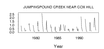
| PointID: | 289 | Code: | 05BH013 | Latitude (decimal degrees): | 51.00 | Longitude (decimal degrees): | -114.93 | Drainage Area (km2): | 36.00 | Source: | Hydat | Hydrological Zone: | Nelson | Name: | JUMPINGPOUND CREEK NEAR COX HILL |
|---|
| Download | |
|---|---|
| Site Descriptor Information | Site Time Series Data |
| Link to all available data | |
| ID | Year | Jan | Feb | Mar | Apr | May | Jun | Jul | Aug | Sep | Oct | Nov | Dec |
|---|---|---|---|---|---|---|---|---|---|---|---|---|---|
| 289 | 1976 | 0.89 | 0.23 | 0.12 | |||||||||
| 289 | 1977 | 0.58 | 0.33 | 0.15 | 0.25 | 0.25 | 0.23 | ||||||
| 289 | 1978 | 1.01 | 1.21 | 0.69 | 0.32 | 0.25 | 0.15 | ||||||
| 289 | 1979 | 0.97 | 0.62 | 0.23 | 0.11 | 0.07 | 0.05 | ||||||
| 289 | 1980 | 0.85 | 1.53 | 0.19 | 0.16 | 0.24 | 0.17 | ||||||
| 289 | 1981 | 2.60 | 2.24 | 0.96 | 0.67 | 0.13 | 0.08 | ||||||
| 289 | 1982 | 0.34 | 1.62 | 0.41 | 0.12 | 0.08 | 0.08 | ||||||
| 289 | 1983 | 1.05 | 0.66 | 0.73 | 0.13 | 0.08 | 0.08 | ||||||
| 289 | 1984 | 0.26 | 0.78 | 0.17 | 0.08 | 0.05 | 0.10 | ||||||
| 289 | 1985 | 0.73 | 0.54 | 0.15 | 0.42 | 1.08 | 0.30 | ||||||
| 289 | 1986 | 1.06 | 0.78 | 0.34 | 0.28 | 0.20 | 0.95 | ||||||
| 289 | 1987 | 0.43 | 0.25 | 0.45 | 0.38 | 0.16 | 0.08 | ||||||
| 289 | 1988 | 0.34 | 0.50 | 0.14 | 0.45 | 0.42 | 0.35 | ||||||
| 289 | 1989 | 0.76 | 0.60 | 0.26 | 0.21 | 0.49 | 0.16 | ||||||
| 289 | 1990 | 2.16 | 1.88 | 0.57 | 0.49 | 0.21 | 0.13 | ||||||
| 289 | 1991 | 1.83 | 1.16 | 0.60 | 0.21 | 0.12 | 0.08 | ||||||
| 289 | 1992 | 0.18 | 1.40 | 1.07 | 0.23 | 0.19 | 0.17 | ||||||
| 289 | 1993 | 0.69 | 1.87 | 2.00 | 1.02 | 0.75 | 0.27 |
 Return to R-Arctic Net Home Page