| PointID: | 2884 | Code: | 05ME008 | Latitude (decimal degrees): | 50.27 | Longitude (decimal degrees): | -101.01 | Drainage Area (km2): | 362.00 | Source: | Hydat | Hydrological Zone: | Nelson | Name: | MINNEWASTA CREEK NEAR BEULAH |
|---|
| Download | |
|---|---|
| Site Descriptor Information | Site Time Series Data |
| Link to all available data | |
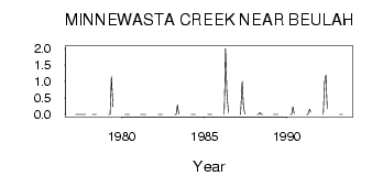
| ID | Year | Jan | Feb | Mar | Apr | May | Jun | Jul | Aug | Sep | Oct | Nov | Dec |
|---|---|---|---|---|---|---|---|---|---|---|---|---|---|
| 2884 | 1977 | 0.00 | 0.00 | 0.00 | 0.00 | 0.00 | 0.00 | 0.00 | 0.00 | ||||
| 2884 | 1978 | 0.00 | 0.00 | 0.00 | 0.00 | ||||||||
| 2884 | 1979 | 0.00 | 0.00 | 1.15 | 0.23 | ||||||||
| 2884 | 1980 | 0.00 | 0.00 | 0.00 | 0.00 | ||||||||
| 2884 | 1981 | 0.00 | 0.00 | 0.00 | 0.00 | 0.00 | |||||||
| 2884 | 1982 | 0.00 | 0.00 | 0.00 | 0.00 | ||||||||
| 2884 | 1983 | 0.00 | 0.00 | 0.29 | 0.02 | ||||||||
| 2884 | 1984 | 0.00 | 0.00 | 0.00 | 0.00 | ||||||||
| 2884 | 1985 | 0.00 | 0.00 | 2.0e-03 | 0.00 | ||||||||
| 2884 | 1986 | 0.00 | 2.00 | 0.68 | 0.06 | ||||||||
| 2884 | 1987 | 0.00 | 1.00 | 0.24 | 0.01 | ||||||||
| 2884 | 1988 | 0.00 | 0.00 | 0.06 | 4.0e-03 | 0.00 | |||||||
| 2884 | 1989 | 0.00 | 0.00 | 1.0e-03 | 0.00 | ||||||||
| 2884 | 1990 | 0.00 | 0.00 | 0.23 | 0.03 | ||||||||
| 2884 | 1991 | 0.00 | 0.00 | 0.16 | 0.07 | ||||||||
| 2884 | 1992 | 0.00 | 1.00 | 1.19 | 0.17 | ||||||||
| 2884 | 1993 | 0.00 | 0.00 | 4.0e-03 |
 Return to R-Arctic Net Home Page