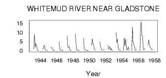
| PointID: | 2851 | Code: | 05LL004 | Latitude (decimal degrees): | 50.21 | Longitude (decimal degrees): | -98.92 | Drainage Area (km2): | 1890.00 | Source: | Hydat | Hydrological Zone: | Nelson | Name: | WHITEMUD RIVER NEAR GLADSTONE |
|---|
| Download | |
|---|---|
| Site Descriptor Information | Site Time Series Data |
| Link to all available data | |
| ID | Year | Jan | Feb | Mar | Apr | May | Jun | Jul | Aug | Sep | Oct | Nov | Dec |
|---|---|---|---|---|---|---|---|---|---|---|---|---|---|
| 2851 | 1943 | 1.00 | 9.00 | 1.81 | 3.79 | 2.76 | 0.87 | 0.11 | 0.23 | ||||
| 2851 | 1944 | 1.00 | 1.27 | 3.02 | 2.38 | 0.27 | 0.36 | 0.40 | 0.00 | ||||
| 2851 | 1945 | 2.00 | 2.02 | 0.99 | 0.72 | 0.11 | 0.10 | 0.27 | |||||
| 2851 | 1946 | 5.00 | 1.13 | 0.46 | 0.40 | 0.05 | 0.05 | 0.40 | |||||
| 2851 | 1947 | 8.00 | 2.42 | 1.81 | 2.24 | 0.36 | 0.10 | 0.15 | |||||
| 2851 | 1948 | 9.00 | 3.99 | 0.49 | 0.29 | 0.42 | 0.08 | 0.17 | |||||
| 2851 | 1949 | 7.00 | 1.36 | 0.75 | 0.34 | 0.46 | 0.03 | 0.28 | 0.00 | ||||
| 2851 | 1950 | 3.00 | 6.54 | 3.70 | 2.98 | 0.79 | 0.39 | 0.40 | |||||
| 2851 | 1951 | 5.00 | 2.47 | 1.52 | 0.29 | 0.26 | 0.29 | 0.66 | |||||
| 2851 | 1952 | 3.00 | 0.84 | 1.56 | 2.23 | 0.34 | 1.26 | 0.33 | 0.00 | ||||
| 2851 | 1953 | 10.00 | 4.51 | 6.41 | 1.87 | 0.38 | 0.25 | 0.38 | 0.00 | ||||
| 2851 | 1954 | 0.00 | 7.00 | 2.69 | 6.48 | 1.98 | 0.26 | 1.05 | 1.97 | 0.00 | |||
| 2851 | 1955 | 0.00 | 13.00 | 4.65 | 3.38 | 2.26 | 0.29 | 0.29 | 0.57 | ||||
| 2851 | 1956 | 0.00 | 12.00 | 16.00 | 8.00 | 7.77 | 0.93 | 0.43 | 1.37 | ||||
| 2851 | 1957 | 3.00 | 6.00 | 3.25 | 2.08 | 1.48 | 0.61 | 0.44 | 0.63 |
 Return to R-Arctic Net Home Page