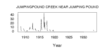
| PointID: | 285 | Code: | 05BH006 | Latitude (decimal degrees): | 51.06 | Longitude (decimal degrees): | -114.54 | Drainage Area (km2): | 455.00 | Source: | Hydat | Hydrological Zone: | Nelson | Name: | JUMPINGPOUND CREEK NEAR JUMPING POUND |
|---|
| Download | |
|---|---|
| Site Descriptor Information | Site Time Series Data |
| Link to all available data | |
| ID | Year | Jan | Feb | Mar | Apr | May | Jun | Jul | Aug | Sep | Oct | Nov | Dec |
|---|---|---|---|---|---|---|---|---|---|---|---|---|---|
| 285 | 1908 | 11.80 | 2.88 | 1.40 | 0.81 | ||||||||
| 285 | 1909 | 6.31 | 5.34 | 3.44 | 1.75 | 0.69 | 0.56 | ||||||
| 285 | 1910 | 0.63 | 1.15 | 0.18 | 0.25 | 1.81 | 0.46 | ||||||
| 285 | 1911 | 3.60 | 6.13 | 5.82 | 10.10 | 5.20 | |||||||
| 285 | 1912 | 4.98 | 5.99 | 20.00 | 6.30 | 4.10 | 2.96 | ||||||
| 285 | 1913 | 4.07 | 6.27 | 3.36 | 3.78 | 1.47 | 0.74 | ||||||
| 285 | 1914 | 1.62 | 1.99 | 1.14 | 0.52 | 0.33 | 0.73 | ||||||
| 285 | 1915 | 0.00 | 9.68 | 29.50 | 27.40 | 6.81 | 3.90 | 3.66 | |||||
| 285 | 1916 | 10.60 | 43.70 | 8.43 | 13.70 | 21.90 | 4.20 | ||||||
| 285 | 1917 | 16.00 | 25.80 | 2.10 | 1.50 | 1.56 | 1.04 | ||||||
| 285 | 1918 | 2.88 | 3.91 | 1.27 | 1.01 | 0.83 | 0.66 | ||||||
| 285 | 1919 | 1.80 | 1.02 | 0.48 | 3.28 | 0.66 | 0.56 | ||||||
| 285 | 1933 | 2.76 | 1.41 | 1.23 |
 Return to R-Arctic Net Home Page