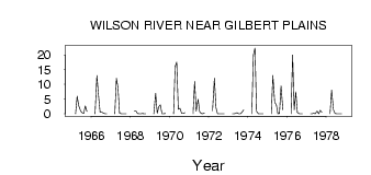
| PointID: | 2842 | Code: | 05LJ035 | Latitude (decimal degrees): | 51.12 | Longitude (decimal degrees): | -100.47 | Drainage Area (km2): | 648.00 | Source: | Hydat | Hydrological Zone: | Nelson | Name: | WILSON RIVER NEAR GILBERT PLAINS |
|---|
| Download | |
|---|---|
| Site Descriptor Information | Site Time Series Data |
| Link to all available data | |
| ID | Year | Jan | Feb | Mar | Apr | May | Jun | Jul | Aug | Sep | Oct | Nov | Dec |
|---|---|---|---|---|---|---|---|---|---|---|---|---|---|
| 2842 | 1965 | 0.00 | 6.00 | 2.79 | 1.03 | 0.36 | 0.10 | 2.73 | 0.83 | ||||
| 2842 | 1966 | 0.00 | 13.00 | 6.34 | 0.68 | 0.59 | 0.29 | 1.0e-03 | 0.00 | ||||
| 2842 | 1967 | 0.00 | 12.00 | 8.80 | 0.19 | 8.0e-03 | 0.00 | 0.00 | 0.00 | ||||
| 2842 | 1968 | 1.00 | 1.00 | 0.10 | 0.01 | 0.05 | 0.10 | 1.0e-03 | 0.00 | ||||
| 2842 | 1969 | 0.00 | 7.00 | 0.21 | 2.41 | 3.03 | 0.01 | 6.0e-03 | 0.08 | ||||
| 2842 | 1970 | 0.00 | 16.00 | 17.60 | 1.51 | 1.87 | 0.16 | 0.10 | 0.41 | ||||
| 2842 | 1971 | 0.00 | 11.00 | 0.89 | 4.95 | 0.75 | 0.11 | 1.0e-03 | 0.29 | ||||
| 2842 | 1972 | 1.00 | 12.00 | 2.10 | 0.04 | 0.00 | 0.00 | 0.00 | 0.00 | ||||
| 2842 | 1973 | 0.00 | 0.00 | 0.12 | 0.38 | 0.01 | 0.01 | 0.53 | 1.25 | ||||
| 2842 | 1974 | 0.00 | 20.00 | 22.30 | 0.81 | 0.02 | 2.0e-03 | 4.0e-03 | 5.0e-03 | ||||
| 2842 | 1975 | 0.00 | 13.00 | 3.86 | 3.14 | 0.04 | 0.15 | 9.47 | 1.36 | ||||
| 2842 | 1976 | 0.00 | 20.00 | 1.33 | 7.42 | 0.45 | 2.0e-03 | 0.00 | 0.00 | ||||
| 2842 | 1977 | 0.00 | 0.00 | 0.19 | 0.03 | 0.90 | 0.05 | 1.20 | 0.44 | ||||
| 2842 | 1978 | 0.00 | 8.00 | 1.38 | 0.09 | 7.0e-03 | 0.00 | 4.0e-03 | 0.05 |
 Return to R-Arctic Net Home Page