| PointID: | 2840 | Code: | 05LJ032 | Latitude (decimal degrees): | 50.98 | Longitude (decimal degrees): | -100.05 | Drainage Area (km2): | 14.80 | Source: | Hydat | Hydrological Zone: | Nelson | Name: | EASTERN TRIBUTARY TO EDWARDS CREEK |
|---|
| Download | |
|---|---|
| Site Descriptor Information | Site Time Series Data |
| Link to all available data | |
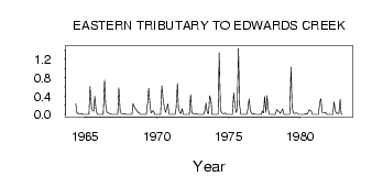
| ID | Year | Jan | Feb | Mar | Apr | May | Jun | Jul | Aug | Sep | Oct | Nov | Dec |
|---|---|---|---|---|---|---|---|---|---|---|---|---|---|
| 2840 | 1964 | 0.23 | 0.02 | 0.03 | 0.01 | 0.01 | 0.02 | 0.00 | 0.00 | ||||
| 2840 | 1965 | 0.00 | 0.00 | 0.00 | 0.00 | 0.61 | 0.21 | 0.09 | 0.07 | 0.39 | 0.09 | 0.00 | 0.00 |
| 2840 | 1966 | 0.00 | 0.00 | 0.00 | 0.00 | 0.75 | 0.23 | 0.04 | 0.04 | 0.02 | 0.02 | 0.00 | 0.00 |
| 2840 | 1967 | 0.00 | 0.00 | 0.00 | 0.00 | 0.58 | 0.09 | 0.02 | 0.02 | 0.01 | 0.02 | 0.00 | 0.00 |
| 2840 | 1968 | 0.00 | 0.00 | 0.00 | 0.00 | 0.24 | 0.16 | 0.13 | 0.09 | 0.05 | 0.04 | 0.00 | 0.00 |
| 2840 | 1969 | 0.00 | 0.00 | 0.00 | 0.00 | 0.25 | 0.57 | 0.22 | 0.03 | 0.07 | 0.08 | 0.00 | 0.00 |
| 2840 | 1970 | 0.00 | 0.00 | 0.00 | 0.00 | 0.62 | 0.31 | 0.18 | 0.04 | 0.13 | 0.23 | 0.00 | 0.00 |
| 2840 | 1971 | 0.00 | 0.00 | 0.00 | 0.00 | 0.14 | 0.68 | 0.12 | 0.04 | 0.02 | 0.13 | 0.00 | 0.00 |
| 2840 | 1972 | 0.00 | 0.00 | 0.00 | 0.00 | 0.43 | 0.04 | 0.02 | 0.01 | 0.01 | 0.02 | 0.00 | 0.00 |
| 2840 | 1973 | 0.00 | 0.00 | 0.00 | 0.00 | 0.09 | 0.25 | 0.03 | 0.02 | 0.41 | 0.31 | 0.00 | 0.00 |
| 2840 | 1974 | 0.00 | 0.00 | 0.00 | 0.00 | 1.34 | 0.10 | 0.04 | 0.02 | 0.02 | 0.03 | 0.00 | 0.00 |
| 2840 | 1975 | 0.00 | 0.00 | 0.00 | 0.00 | 0.47 | 0.23 | 0.04 | 0.09 | 1.44 | 0.21 | 0.00 | 0.00 |
| 2840 | 1976 | 0.00 | 0.00 | 0.00 | 0.00 | 0.13 | 0.34 | 0.08 | 0.03 | 0.01 | 0.02 | 0.00 | 0.00 |
| 2840 | 1977 | 0.00 | 0.00 | 0.00 | 0.00 | 0.07 | 0.03 | 0.39 | 0.05 | 0.41 | 0.10 | 0.00 | 0.00 |
| 2840 | 1978 | 0.00 | 0.00 | 0.00 | 0.00 | 0.11 | 0.08 | 0.06 | 0.02 | 0.07 | 0.12 | 0.00 | 0.00 |
| 2840 | 1979 | 0.00 | 0.00 | 0.00 | 0.00 | 1.03 | 0.15 | 0.03 | 0.02 | 0.03 | 0.03 | 0.00 | 0.00 |
| 2840 | 1980 | 0.00 | 0.00 | 0.00 | 0.00 | 0.02 | 0.01 | 0.02 | 0.10 | 0.09 | 0.07 | 0.00 | 0.00 |
| 2840 | 1981 | 0.00 | 0.00 | 0.00 | 0.00 | 0.27 | 0.34 | 0.04 | 0.03 | 0.03 | 0.04 | 0.00 | 0.00 |
| 2840 | 1982 | 0.00 | 0.00 | 0.00 | 0.00 | 0.28 | 0.09 | 0.02 | 0.03 | 0.02 | 0.33 | 0.00 | 0.00 |
 Return to R-Arctic Net Home Page