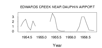
| PointID: | 2830 | Code: | 05LJ020 | Latitude (decimal degrees): | 51.10 | Longitude (decimal degrees): | -100.06 | Drainage Area (km2): | 138.00 | Source: | Hydat | Hydrological Zone: | Nelson | Name: | EDWARDS CREEK NEAR DAUPHIN AIRPORT |
|---|
| Download | |
|---|---|
| Site Descriptor Information | Site Time Series Data |
| Link to all available data | |
| ID | Year | Jan | Feb | Mar | Apr | May | Jun | Jul | Aug | Sep | Oct | Nov | Dec |
|---|---|---|---|---|---|---|---|---|---|---|---|---|---|
| 2830 | 1954 | 1.00 | 1.97 | 2.52 | 0.94 | 0.23 | 2.13 | 1.05 | |||||
| 2830 | 1955 | 2.00 | 3.76 | 2.79 | 0.33 | 0.09 | 0.02 | 0.06 | |||||
| 2830 | 1956 | 0.00 | 1.00 | 3.01 | 3.01 | 1.54 | 0.24 | 0.18 | 0.14 |
 Return to R-Arctic Net Home Page