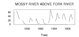
| PointID: | 2824 | Code: | 05LJ014 | Latitude (decimal degrees): | 51.50 | Longitude (decimal degrees): | -99.99 | Drainage Area (km2): | 9030.00 | Source: | Hydat | Hydrological Zone: | Nelson | Name: | MOSSY RIVER ABOVE FORK RIVER |
|---|
| Download | |
|---|---|
| Site Descriptor Information | Site Time Series Data |
| Link to all available data | |
| ID | Year | Jan | Feb | Mar | Apr | May | Jun | Jul | Aug | Sep | Oct | Nov | Dec |
|---|---|---|---|---|---|---|---|---|---|---|---|---|---|
| 2824 | 1948 | 64.30 | 61.50 | 59.20 | 50.40 | 40.90 | 31.40 | 26.00 | |||||
| 2824 | 1949 | 16.00 | 15.80 | 12.20 | 6.44 | 2.74 | 1.33 | 1.18 | 1.00 | ||||
| 2824 | 1950 | 12.00 | 11.80 | 28.70 | 30.30 | 25.00 | 18.90 | 19.80 | 17.00 | ||||
| 2824 | 1951 | 17.00 | 27.10 | 20.50 | 8.79 | 4.64 | 4.14 | 4.69 | 4.00 | ||||
| 2824 | 1952 | 26.00 | 25.30 | 11.80 | 5.20 | 2.57 | 2.06 | 1.70 | 1.00 | ||||
| 2824 | 1953 | 6.00 | 18.00 | 28.20 | 69.60 | 68.20 | 54.10 | 41.80 | 34.50 | 31.00 | |||
| 2824 | 1954 | 15.00 | 21.00 | 29.50 | 54.80 | 53.40 | 35.50 | 33.50 | 34.60 | 29.00 | |||
| 2824 | 1955 | 24.00 | 38.00 | 49.60 | 52.20 | 48.50 | 35.30 | 27.20 | 21.00 | ||||
| 2824 | 1956 | 12.00 | 16.00 | 39.50 | 39.00 | 48.80 | 38.00 | 30.40 | 24.10 |
 Return to R-Arctic Net Home Page