| PointID: | 2820 | Code: | 05LJ010 | Latitude (decimal degrees): | 51.27 | Longitude (decimal degrees): | -100.01 | Drainage Area (km2): | 2880.00 | Source: | Hydat | Hydrological Zone: | Nelson | Name: | VALLEY RIVER NEAR DAUPHIN |
|---|
| Download | |
|---|---|
| Site Descriptor Information | Site Time Series Data |
| Link to all available data | |
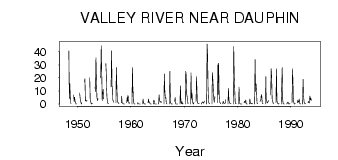
| ID | Year | Jan | Feb | Mar | Apr | May | Jun | Jul | Aug | Sep | Oct | Nov | Dec |
|---|---|---|---|---|---|---|---|---|---|---|---|---|---|
| 2820 | 1948 | 40.70 | 4.35 | 15.70 | 6.10 | 1.01 | 0.50 | ||||||
| 2820 | 1949 | 7.00 | 2.05 | 5.14 | 2.15 | 1.40 | 0.04 | 0.04 | |||||
| 2820 | 1950 | 8.47 | 6.29 | 3.08 | 1.60 | 0.11 | 1.04 | ||||||
| 2820 | 1951 | 17.00 | 19.30 | 2.59 | 3.26 | 2.09 | 2.71 | 2.73 | |||||
| 2820 | 1952 | 20.00 | 3.36 | 1.82 | 0.48 | 0.03 | 0.36 | 0.25 | |||||
| 2820 | 1953 | 13.00 | 9.49 | 35.40 | 17.70 | 5.44 | 2.63 | 4.11 | 4.00 | ||||
| 2820 | 1954 | 20.00 | 22.20 | 44.60 | 24.80 | 2.65 | 9.27 | 11.20 | 4.00 | ||||
| 2820 | 1955 | 31.00 | 23.60 | 13.10 | 4.58 | 1.67 | 0.37 | 0.58 | |||||
| 2820 | 1956 | 13.00 | 40.80 | 13.60 | 13.40 | 3.56 | 2.28 | 1.30 | |||||
| 2820 | 1957 | 1.00 | 28.00 | 13.60 | 3.05 | 1.17 | 1.14 | 0.38 | 0.34 | ||||
| 2820 | 1958 | 1.00 | 6.00 | 1.04 | 0.57 | 0.40 | 0.03 | 0.01 | 0.03 | ||||
| 2820 | 1959 | 1.00 | 5.00 | 2.08 | 6.57 | 5.18 | 0.80 | 0.60 | 0.92 | ||||
| 2820 | 1960 | 0.00 | 28.00 | 8.92 | 9.21 | 1.32 | 0.29 | 0.03 | 0.00 | ||||
| 2820 | 1961 | 0.00 | 1.00 | 0.84 | 0.09 | 0.00 | 0.00 | 0.00 | 0.00 | ||||
| 2820 | 1962 | 0.00 | 4.00 | 1.13 | 0.51 | 0.02 | 1.0e-03 | 1.0e-03 | 0.00 | ||||
| 2820 | 1963 | 1.00 | 4.00 | 1.35 | 1.76 | 1.20 | 0.04 | 1.0e-03 | 0.00 | ||||
| 2820 | 1964 | 0.00 | 3.00 | 2.18 | 0.08 | 7.0e-03 | 0.00 | 0.00 | 0.00 | ||||
| 2820 | 1965 | 0.00 | 7.00 | 3.15 | 1.31 | 1.76 | 1.84 | 1.67 | 1.33 | ||||
| 2820 | 1966 | 0.00 | 23.00 | 9.74 | 4.64 | 5.10 | 0.86 | 0.29 | 0.12 | ||||
| 2820 | 1967 | 0.00 | 25.00 | 12.80 | 0.95 | 0.18 | 0.02 | 0.00 | 2.0e-03 | ||||
| 2820 | 1968 | 2.00 | 5.00 | 0.58 | 0.12 | 0.01 | 0.01 | 8.0e-03 | 3.0e-03 | ||||
| 2820 | 1969 | 0.00 | 14.00 | 1.14 | 0.22 | 2.02 | 0.90 | 0.08 | 0.56 | ||||
| 2820 | 1970 | 0.00 | 25.00 | 22.10 | 7.70 | 5.51 | 2.91 | 0.44 | 0.88 | ||||
| 2820 | 1971 | 0.00 | 24.00 | 3.73 | 8.42 | 2.42 | 0.73 | 0.06 | 1.15 | ||||
| 2820 | 1972 | 2.00 | 21.00 | 8.86 | 2.61 | 0.85 | 0.42 | 0.55 | 0.60 | ||||
| 2820 | 1973 | 0.00 | 1.00 | 0.93 | 1.64 | 1.22 | 0.54 | 1.40 | 2.22 | ||||
| 2820 | 1974 | 0.00 | 46.00 | 38.40 | 13.00 | 2.14 | 0.66 | 0.42 | 0.57 | ||||
| 2820 | 1975 | 0.00 | 24.00 | 18.80 | 11.60 | 3.75 | 1.32 | 5.76 | 4.73 | ||||
| 2820 | 1976 | 1.00 | 30.00 | 7.04 | 31.30 | 9.36 | 1.66 | 1.14 | 0.20 | ||||
| 2820 | 1977 | 0.00 | 2.00 | 1.32 | 0.70 | 0.62 | 0.47 | 1.20 | 3.45 | ||||
| 2820 | 1978 | 0.00 | 12.00 | 3.23 | 1.19 | 0.56 | 0.38 | 0.27 | 0.27 | ||||
| 2820 | 1979 | 0.00 | 44.00 | 22.30 | 12.30 | 1.85 | 0.35 | 0.23 | 0.26 | ||||
| 2820 | 1980 | 0.00 | 13.00 | 1.22 | 0.21 | 0.05 | 0.13 | 0.07 | 0.10 | ||||
| 2820 | 1981 | 1.00 | 2.00 | 1.28 | 1.25 | 3.16 | 0.26 | 0.04 | 0.07 | ||||
| 2820 | 1982 | 0.00 | 4.00 | 1.48 | 0.48 | 0.28 | 0.68 | 0.11 | 0.51 | ||||
| 2820 | 1983 | 0.00 | 34.00 | 9.69 | 15.40 | 9.84 | 1.22 | 0.26 | 0.32 | ||||
| 2820 | 1984 | 2.00 | 3.00 | 3.24 | 7.29 | 5.75 | 0.55 | 0.19 | 0.43 | ||||
| 2820 | 1985 | 0.00 | 21.00 | 4.11 | 3.17 | 0.87 | 1.13 | 1.73 | 2.58 | ||||
| 2820 | 1986 | 7.00 | 27.00 | 21.40 | 4.30 | 2.95 | 1.56 | 0.45 | 0.62 | ||||
| 2820 | 1987 | 1.00 | 27.00 | 2.84 | 0.83 | 0.68 | 0.21 | 0.01 | 0.42 | ||||
| 2820 | 1988 | 0.00 | 14.00 | 28.00 | 3.27 | 0.50 | 0.04 | 0.01 | 0.12 | ||||
| 2820 | 1989 | 0.00 | 1.00 | 0.58 | 1.53 | 0.63 | 0.05 | 0.25 | 0.41 | ||||
| 2820 | 1990 | 1.00 | 27.00 | 16.20 | 5.25 | 1.53 | 0.12 | 0.02 | 0.43 | ||||
| 2820 | 1991 | 1.00 | 3.00 | 1.46 | 1.55 | 3.97 | 1.32 | 0.08 | 0.25 | ||||
| 2820 | 1992 | 0.00 | 19.00 | 6.38 | 1.89 | 0.41 | 0.11 | 0.17 | 0.32 | ||||
| 2820 | 1993 | 1.00 | 2.00 | 1.62 | 0.73 | 6.09 | 3.20 | 4.83 | 2.74 |
 Return to R-Arctic Net Home Page