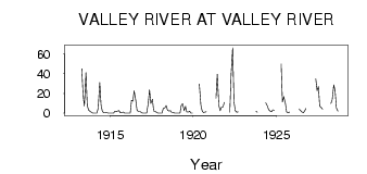
| PointID: | 2817 | Code: | 05LJ004 | Latitude (decimal degrees): | 51.25 | Longitude (decimal degrees): | -100.14 | Drainage Area (km2): | 2720.00 | Source: | Hydat | Hydrological Zone: | Nelson | Name: | VALLEY RIVER AT VALLEY RIVER |
|---|
| Download | |
|---|---|
| Site Descriptor Information | Site Time Series Data |
| Link to all available data | |
| ID | Year | Jan | Feb | Mar | Apr | May | Jun | Jul | Aug | Sep | Oct | Nov | Dec |
|---|---|---|---|---|---|---|---|---|---|---|---|---|---|
| 2817 | 1912 | 5.00 | |||||||||||
| 2817 | 1913 | 45.00 | 18.60 | 7.22 | 41.10 | 8.07 | 3.02 | 1.85 | 1.00 | 0.00 | |||
| 2817 | 1914 | 0.00 | 0.00 | 0.00 | 5.00 | 31.20 | 8.06 | 1.92 | 0.33 | 0.44 | 0.57 | 0.00 | 0.00 |
| 2817 | 1915 | 0.00 | 0.00 | 0.00 | 2.00 | 1.50 | 2.15 | 2.56 | 0.25 | 0.58 | 1.08 | 0.00 | 0.00 |
| 2817 | 1916 | 0.00 | 0.00 | 0.00 | 13.00 | 12.30 | 22.50 | 13.30 | 3.06 | 1.75 | 1.73 | 1.00 | 0.00 |
| 2817 | 1917 | 0.00 | 0.00 | 0.00 | 10.00 | 23.60 | 9.84 | 14.10 | 2.20 | 1.97 | 0.95 | 0.00 | 0.00 |
| 2817 | 1918 | 0.00 | 0.00 | 5.00 | 5.00 | 7.88 | 3.09 | 2.33 | 2.51 | 0.86 | 0.81 | 0.00 | 0.00 |
| 2817 | 1919 | 0.00 | 0.00 | 0.00 | 8.00 | 9.54 | 2.41 | 6.94 | 1.20 | 1.06 | 1.95 | 0.00 | 0.00 |
| 2817 | 1920 | 29.40 | 8.25 | 2.27 | 0.60 | 1.24 | 1.29 | ||||||
| 2817 | 1921 | 15.30 | 39.60 | 8.12 | 2.34 | 6.02 | 6.36 | 11.00 | |||||
| 2817 | 1922 | 1.00 | 39.00 | 66.40 | 11.70 | 2.54 | 0.85 | 1.28 | |||||
| 2817 | 1923 | 1.88 | 1.00 | ||||||||||
| 2817 | 1924 | 10.50 | 7.45 | 3.56 | 2.09 | 1.40 | 3.34 | 3.00 | |||||
| 2817 | 1925 | 50.00 | 11.40 | 16.80 | 10.40 | 1.32 | 0.48 | 1.12 | |||||
| 2817 | 1926 | 4.42 | 2.67 | 1.30 | 0.30 | 2.31 | 4.93 | ||||||
| 2817 | 1927 | 34.70 | 22.90 | 27.10 | 7.35 | 5.67 | 4.06 | ||||||
| 2817 | 1928 | 10.00 | 13.60 | 28.70 | 23.00 | 5.48 | 2.05 |
 Return to R-Arctic Net Home Page